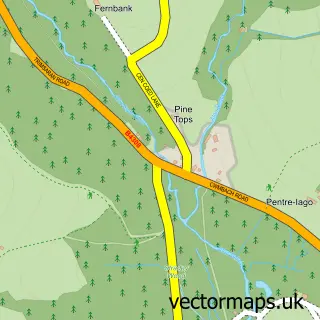
This Dafen street map is a detailed vector street map covering a 750m x 750m area. Select a larger area to create and download your own vector street map of Dafen.
The 750-metre map sample for Dafen covers 191 mapped buildings and approximately 12.1 km of road detail, of which 11 named roads are named. The immediate area includes 1 pub and 1 MOT station, with 14 within 2 miles. The wider area around Dafen features 1 tourism point of interest, 2 food and drink venues and 1 campsite within 2 miles. To create a larger or custom map of Dafen, the map builder lets you define your own coverage area and download editable SVG, PDF and PNG files.
Create a larger editable map of Dafen
Choose any area you need and generate a high-quality vector map instantly. Perfect for print, planning, design, business and personal use.

This Dafen street map in Dyfed is available as downloadable SVG, PDF and PNG map files, or as a printed map for planning, business, display, education, local information and design work. You can also create a larger custom map area using the map selector.
What this Dafen map sample shows
Dafen lies within Llanelli Rural Community parish, part of Dafen ward in the Sir Gaerfyrddin - Carmarthenshire local authority area. The postcode geography for this area includes the SA postcode area, the SA14 postcode district and the SA14 8 postcode sector. Residents fall under the Hywel Dda University Health Board for NHS services.
Local features near Dafen
Within 2 milesAmenities and services in and around Dafen.
Administrative and postcode information for Dafen
The local authority covering Dafen is Sir Gaerfyrddin - Carmarthenshire, within the county of Dyfed. The settlement lies within Dafen ward and Llanelli Rural Community civil parish. The SA14 postcode district and SA14 8 postcode sector serve the immediate area. NHS provision in the area is delivered through Hywel Dda University Health Board.
Nearby street map samples around Dafen


More street maps in Dyfed
750 metre map area coverage
Boundary, postcode and point of interest information for the 750m x 750m rectangle centred on this sample map.
Boundaries containing map centre
Constituency: Llanelli Co Const
District: Sir Gaerfyrddin - Carmarthenshire
Icb: Hywel Dda
Parish: Llanelli Rural Community
Police Force: dyfed-powys
Postcode District: SA14
Postcode Sector: SA14 8
Nearby boundaries intersecting sample
Postcode Sector: SA14 9
Postcode coverage
POI category counts
Automotive Repair: 3
Car Rental Agency: 3
Gym: 3
Bar: 2
Church Cathedral: 2
Gas Station: 2
Shipping Center: 2
Used Car Dealer: 2
Alternative Medicine: 1
Ambulance And Ems Services: 1
Sample points of interest
- F. Sian Griffiths Osteopathy
- South Wales Medical Event Cover
- Dafen Church
- Williams Architecture
- AMS Commercials Ltd
- Dafen MOT Centre
- FMP Motor Factors
- InstaVolt Charging Station
- BUSH INN
- Nevills Arms
- Mychyns Beach
- Glam Tan Hair and Beauty
Create a larger editable map of Dafen
This sample shows only a 750 metre area. To create a larger map of Dafen, use our map builder to choose your own coverage area, add titles and download editable SVG, PDF and PNG files.
Create a custom map of Dafen