Vector Maps logo
Home Why it works Popular maps Districts Samples Customizer Create Your Map
VectorMaps.uk
Home Popular maps Districts Samples Customizer Create Your Map Privacy Disclaimer
Home / UK Maps / Inverness / Inverness Map

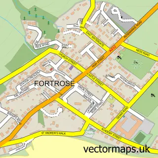
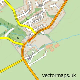
This Inverness street map is a detailed vector street map covering a 750m x 750m area. Select a larger area to create and download your own vector street map of Inverness.

Inverness is a city in Inverness, in the Highlands And Islands of Scotland. Historically, the area formed part of Inverness-Shire. The settlement falls within the Inverness, Nairn, Badenoch And Strathspey parliamentary constituency. It is served by the IV

The 750-metre map sample for Inverness covers 73 mapped buildings and approximately 24.0 km of road detail, of which 60 named roads are named. The immediate area includes 1 railway station, 9 GP surgeries within 2 miles, 33 pubs and 1 MOT station, with 16 within 2 miles. The wider area around Inverness features 22 tourism points of interest, 115 food and drink venues and 33 hotels. To create a larger or custom map of Inverness, the map builder lets you define your own coverage area and download editable SVG, PDF and PNG files.

73Buildings
24 kmRoads
60Named roads
0Residents within 2 miles
Create your own

Create a larger editable map of Inverness

Choose any area you need and generate a high-quality vector map instantly. Perfect for print, planning, design, business and personal use.

Choose any location
Editable SVG files
Any size up to A0
PDF, PNG & more
Instant download
High quality guaranteed
Create My Custom Map
Secure, private & no credit card required
Inverness Vector Street Map
750m Sample
Inverness vector street map sample showing roads, buildings and local features in a 750 metre preview area
Buy Inverness Map Print from £12.95 Buy Inverness Digital Map from £6

This Inverness street map in Inverness is available as downloadable SVG, PDF and PNG map files, or as a printed map for planning, business, display, education, local information and design work. You can also create a larger custom map area using the map selector.

What this Inverness map sample shows

Inverness lies within Highland parish, part of Inverness Millburn ward in the Highland local authority area. The postcode geography for this area includes the IV postcode area, the IV2 postcode district and the IV2 3 postcode sector. Residents fall under the Highland for NHS services.

Local features near Inverness

Within 2 miles

Amenities and services in and around Inverness.

1 Railway stations
1 Campsites within 2 miles
9 GP surgeries within 2 miles
1 MOT stations 16 within 2 miles
22 Tourism & leisure
115 Food & drink
33 Pubs
33 Hotels
12 Healthcare POIs
7 Vehicle services

Counts are approximate and based on publicly available data.

Administrative and postcode information for Inverness

The local authority covering Inverness is Highland, within the county of Inverness. The settlement lies within Inverness Millburn ward and Highland civil parish. The IV2 postcode district and IV2 3 postcode sector serve the immediate area. NHS provision in the area is delivered through Highland.

Parish HIGHLAND
Ward Inverness Millburn
District / local authority Highland
County Inverness
Historic county Inverness-shire
Postcode district IV2
Postcode sector IV2 3
Parliamentary constituency Inverness, Nairn, Badenoch and Strathspey
Region Highlands and Islands
Country Scotland

Nearby street map samples around Inverness

Street map sample of Fortrose, Ross and Cromarty Fortrose Town - Ross and Cromarty - 7.9 miles Street map sample of North Kessock, Ross and Cromarty North Kessock Village - Ross and Cromarty - 1.7 miles Street map sample of Charleston, Ross and Cromarty Charleston Village - Ross and Cromarty - 2.4 miles Street map sample of Kilmuir, Ross and Cromarty Kilmuir Village - Ross and Cromarty - 2.7 miles Street map sample of Munlochy, Ross and Cromarty Munlochy Village - Ross and Cromarty - 5.0 miles Street map sample of Daviot, Inverness Daviot Village - Inverness - 5.1 miles Street map sample of Newlands of Culloden, Inverness Newlands of Culloden Village - Inverness - 5.8 miles Street map sample of Tore, Ross and Cromarty Tore Village - Ross and Cromarty - 5.8 miles Street map sample of Inchmore, Inverness Inchmore Village - Inverness - 6.1 miles Street map sample of Avoch, Ross and Cromarty Avoch Village - Ross and Cromarty - 6.4 miles

More street maps in Inverness

Street map sample of Daviot, Inverness Daviot Village - 5.1 miles Street map sample of Newlands of Culloden, Inverness Newlands of Culloden Village - 5.8 miles Street map sample of Inchmore, Inverness Inchmore Village - 6.1 miles Street map sample of Inverarnie, Inverness Inverarnie Village - 6.7 miles Street map sample of Kirkhill, Inverness Kirkhill Village - 6.9 miles

750 metre map area coverage

Boundary, postcode and point of interest information for the 750m x 750m rectangle centred on this sample map.

Boundaries containing map centre

Constituency: Inverness, Skye and West Ross-shire Co Const

District: Highland

Icb: Highland

Postcode District: IV1

Postcode Sector: IV1 1

Ward: Inverness Central Ward

Nearby boundaries intersecting sample

Postcode District: IV2, IV3

Postcode Sector: IV2 3, IV3 5

Ward: Inverness Millburn Ward, Inverness West Ward

Postcode coverage

IV1 IV1 1 IV2 IV3 IV2 3 IV3 5

POI category counts

Cafe: 35

Hotel: 33

Pub: 33

Beauty Salon: 32

Clothing Store: 31

Restaurant: 30

Hair Salon: 24

Bar: 19

Professional Services: 18

Coffee Shop: 17

Sample points of interest

  • Donald A M Mclucas Accountant
  • Frame Kennedy Accountant
  • Fitness centre Active Life
  • Great Glen Way Active Life
  • Adult Basic Education Unit Adult Education
  • Private Eyes Inverness Adult Entertainment
  • Inverness Airport, Scotland Airport
  • British Red Cross Antique Store
  • Save The Children Antique Store
  • Unique & antiques Antique Store
  • Gunsmiths Appliance Repair Service
  • Panasonic Store Appliance Store

Create a larger editable map of Inverness

This sample shows only a 750 metre area. To create a larger map of Inverness, use our map builder to choose your own coverage area, add titles and download editable SVG, PDF and PNG files.

Create a custom map of Inverness

Phone 01751 473136 | Copyright Vectormaps.uk 2026

Samples Customizer Privacy Disclaimer
Inverness Vector Street Map
Inverness enlarged street map sample showing a 750 metre preview area