Vector Maps logo
Home Why it works Popular maps Districts Samples Customizer Create Your Map
VectorMaps.uk
Home Popular maps Districts Samples Customizer Create Your Map Privacy Disclaimer
Home / UK Maps / Western Isles / An t-Òb Map

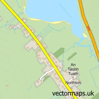
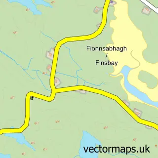
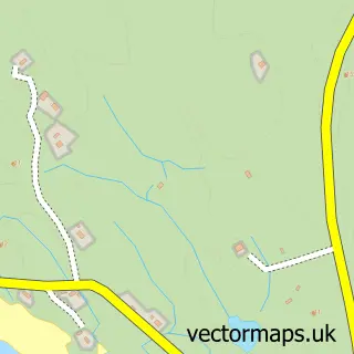
This An t-Òb street map is a detailed vector street map covering a 750m x 750m area. Select a larger area to create and download your own vector street map of An t-Òb.

An t-Òb is a village in Western Isles, in the Highlands And Islands of Scotland. Historically, the area formed part of Inverness-Shire. The settlement falls within the Na H-Eileanan An Iar parliamentary constituency. It is served by the HS5 postcode distr

The 750-metre map sample for An t-Òb covers 31 mapped buildings and approximately 7.1 km of road detail, of which 3 named roads are named. The immediate area includes 1 GP surgery within 2 miles. To create a larger or custom map of An t-Òb, the map builder lets you define your own coverage area and download editable SVG, PDF and PNG files.

31Buildings
7.06 kmRoads
3Named roads
0Residents within 2 miles
Create your own

Create a larger editable map of An t-Òb

Choose any area you need and generate a high-quality vector map instantly. Perfect for print, planning, design, business and personal use.

Choose any location
Editable SVG files
Any size up to A0
PDF, PNG & more
Instant download
High quality guaranteed
Create My Custom Map
Secure, private & no credit card required
An t-Òb Vector Street Map
750m Sample
An t-Òb vector street map sample showing roads, buildings and local features in a 750 metre preview area
Buy An t-Òb Map Print from £12.95 Buy An t-Òb Digital Map from £6

This An t-Òb street map in Western Isles is available as downloadable SVG, PDF and PNG map files, or as a printed map for planning, business, display, education, local information and design work. You can also create a larger custom map area using the map selector.

What this An t-Òb map sample shows

An t-Òb lies within Na H-Eileanan An Iar parish, part of Na Hearadh Agus Ceann A Deas Nan Loch ward in the Na H-Eileanan An Iar local authority area. The postcode geography for this area includes the HS postcode area, the HS5 postcode district and the HS5 3 postcode sector. Residents fall under the Western Isles for NHS services.

Local features near An t-Òb

Within 2 miles

Amenities and services in and around An t-Òb.

1 GP surgeries within 2 miles

Counts are approximate and based on publicly available data.

Administrative and postcode information for An t-Òb

The local authority covering An t-Òb is Na H-Eileanan An Iar, within the county of Western Isles. The settlement lies within Na Hearadh Agus Ceann A Deas Nan Loch ward and Na H-Eileanan An Iar civil parish. The HS5 postcode district and HS5 3 postcode sector serve the immediate area. NHS provision in the area is delivered through Western Isles.

Parish NA H-EILEANAN AN IAR
Ward Na Hearadh agus Ceann a Deas nan Loch
District / local authority Na h-Eileanan an Iar
County Western Isles
Historic county Inverness-shire
Postcode district HS5
Postcode sector HS5 3
Parliamentary constituency Na h-Eileanan an Iar
Region Highlands and Islands
Country Scotland

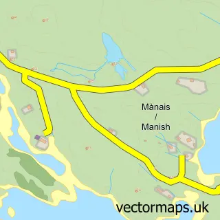
Nearby street map samples around An t-Òb

Street map sample of Steòrnabhagh, Western Isles Steòrnabhagh Town - Western Isles - 38.0 miles Street map sample of Inverness, Inverness Inverness City - Inverness - 105.3 miles Street map sample of Srannda, Western Isles Srannda Village - Western Isles - 1.8 miles Street map sample of An Taobh Tuath, Western Isles An Taobh Tuath Village - Western Isles - 2.6 miles Street map sample of Roghadal, Western Isles Roghadal Village - Western Isles - 2.7 miles Street map sample of Fionnsbhagh, Western Isles Fionnsbhagh Village - Western Isles - 3.6 miles Street map sample of Sgarasta, Western Isles Sgarasta Village - Western Isles - 3.9 miles Street map sample of Na Buirgh, Western Isles Na Buirgh Village - Western Isles - 4.9 miles Street map sample of Mànais, Western Isles Mànais Village - Western Isles - 5.6 miles Street map sample of Ruisigearraidh, Western Isles Ruisigearraidh Village - Western Isles - 6.1 miles

More street maps in Western Isles

Street map sample of Srannda, Western Isles Srannda Village - 1.8 miles Street map sample of An Taobh Tuath, Western Isles An Taobh Tuath Village - 2.6 miles Street map sample of Roghadal, Western Isles Roghadal Village - 2.7 miles Street map sample of Fionnsbhagh, Western Isles Fionnsbhagh Village - 3.6 miles Street map sample of Sgarasta, Western Isles Sgarasta Village - 3.9 miles

750 metre map area coverage

Boundary, postcode and point of interest information for the 750m x 750m rectangle centred on this sample map.

Boundaries containing map centre

Icb: Western Isles

Nearby boundaries intersecting sample

Constituency: Na h-Eileanan an Iar Co Const

District: Na h-Eileanan an Iar

Postcode District: HS5

Postcode Sector: HS5 3

Ward: Na Hearadh Ward

Postcode coverage

HS5 HS5 3

POI category counts

Post Office: 2

Accommodation: 1

Beauty And Spa: 1

Boat Tours: 1

Community Center: 1

Convenience Store: 1

Elementary School: 1

Emergency Service: 1

Grocery Store: 1

Sample points of interest

  • Scalpay Accommodation
  • A.S Apothecary Beauty And Spa
  • Sea Harris Boat Tours
  • Leverhulme Community Hub - Isle of Harris Community Center
  • An Clachan Convenience Store
  • Leverhulme Memorial Primary School Elementary School
  • RNLI Leverburgh Lifeboat Station Emergency Service
  • Harris Community Shop Grocery Store
  • Leverburgh Mobile Service Post Office Post Office
  • Post Office-Leverburgh Mobile Service Post Office

Create a larger editable map of An t-Òb

This sample shows only a 750 metre area. To create a larger map of An t-Òb, use our map builder to choose your own coverage area, add titles and download editable SVG, PDF and PNG files.

Create a custom map of An t-Òb

Phone 01751 473136 | Copyright Vectormaps.uk 2026

Samples Customizer Privacy Disclaimer
An t-Òb Vector Street Map
An t-Òb enlarged street map sample showing a 750 metre preview area