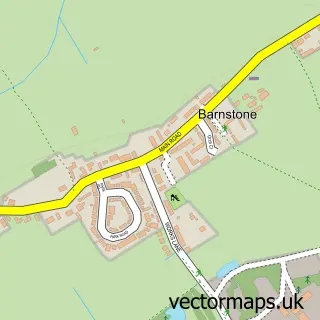
This Barkestone street map is a detailed vector street map covering a 750m x 750m area. Select a larger area to create and download your own vector street map of Barkestone.
The 750-metre map sample for Barkestone covers 134 mapped buildings and approximately 13.5 km of road detail, of which 14 named roads are named. The wider area around Barkestone features 1 tourism point of interest. To create a larger or custom map of Barkestone, the map builder lets you define your own coverage area and download editable SVG, PDF and PNG files.
Create a larger editable map of Barkestone
Choose any area you need and generate a high-quality vector map instantly. Perfect for print, planning, design, business and personal use.

This Barkestone street map in Leicestershire is available as downloadable SVG, PDF and PNG map files, or as a printed map for planning, business, display, education, local information and design work. You can also create a larger custom map area using the map selector.
What this Barkestone map sample shows
Barkestone lies within Redmile Cp parish, part of Long Clawson And Stathern ward in the Melton District (B) local authority area. The postcode geography for this area includes the NG postcode area, the NG13 postcode district and the NG13 0 postcode sector. Residents fall under the Nhs Leicester, Leicestershire And Rutland Integrated Care Board for NHS services.
Local features near Barkestone
Within 2 milesAmenities and services in and around Barkestone.
Administrative and postcode information for Barkestone
Barkestone lies within Redmile Cp parish, part of Long Clawson And Stathern ward in the Melton District (B) local authority area. The postcode geography for this area includes the NG postcode area, the NG13 postcode district and the NG13 0 postcode sector. Residents fall under the Nhs Leicester, Leicestershire And Rutland Integrated Care Board for NHS services.
Nearby street map samples around Barkestone

More street maps in Leicestershire
750 metre map area coverage
Boundary, postcode and point of interest information for the 750m x 750m rectangle centred on this sample map.
Boundaries containing map centre
Constituency: Melton and Syston Co Const
County: Leicestershire County
District: Melton District (B)
Icb: NHS Leicester Leicestershire and Rutland ICB
Parish: Redmile CP
Police Force: leicestershire
Postcode District: NG13
Postcode Sector: NG13 0
Ward: Long Clawson and Stathern Ward
Nearby boundaries intersecting sample
No additional intersecting boundaries found.
Postcode coverage
POI category counts
Anglican Church: 1
Cottage: 1
Environmental And Ecological Services For Businesses: 1
Gas Station: 1
Landmark And Historical Building: 1
Post Office: 1
Sample points of interest
- Barkestone: St Peter & St Paul
- Cherry Tree Holiday Cottage
- Fire Safety FM
- Shell
- Barkestone-le-Vale
- Post Office
Create a larger editable map of Barkestone
This sample shows only a 750 metre area. To create a larger map of Barkestone, use our map builder to choose your own coverage area, add titles and download editable SVG, PDF and PNG files.
Create a custom map of Barkestone