Vector Maps logo
Home Why it works Popular maps Districts Samples Customizer Create Your Map
VectorMaps.uk
Home Popular maps Districts Samples Customizer Create Your Map Privacy Disclaimer
Home / UK Maps / Aberdeenshire / Braemar Map

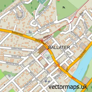
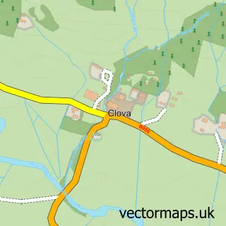
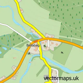
This Braemar street map is a detailed vector street map covering a 750m x 750m area. Select a larger area to create and download your own vector street map of Braemar.

Braemar is a village in Aberdeenshire, in the North East Scotland of Scotland. The settlement falls within the West Aberdeenshire And Kincardine parliamentary constituency. It is served by the AB35 postcode district, with AB35 5 as the local postcode sect

The 750-metre map sample for Braemar covers 141 mapped buildings and approximately 15.6 km of road detail, of which 20 named roads are named. The immediate area includes 1 GP surgery, 2 pubs and 1 MOT station. The wider area around Braemar features 9 tourism points of interest, 6 food and drink venues and 9 hotels. To create a larger or custom map of Braemar, the map builder lets you define your own coverage area and download editable SVG, PDF and PNG files.

141Buildings
15.57 kmRoads
20Named roads
0Residents within 2 miles
Create your own

Create a larger editable map of Braemar

Choose any area you need and generate a high-quality vector map instantly. Perfect for print, planning, design, business and personal use.

Choose any location
Editable SVG files
Any size up to A0
PDF, PNG & more
Instant download
High quality guaranteed
Create My Custom Map
Secure, private & no credit card required
Braemar Vector Street Map
750m Sample
Braemar vector street map sample showing roads, buildings and local features in a 750 metre preview area
Buy Braemar Map Print from £12.95 Buy Braemar Digital Map from £6

This Braemar street map in Aberdeenshire is available as downloadable SVG, PDF and PNG map files, or as a printed map for planning, business, display, education, local information and design work. You can also create a larger custom map area using the map selector.

What this Braemar map sample shows

Braemar lies within Aberdeenshire parish, part of Aboyne, Upper Deeside And Donside ward in the Aberdeenshire local authority area. The postcode geography for this area includes the AB postcode area, the AB35 postcode district and the AB35 5 postcode sector. Residents fall under the Grampian for NHS services.

Local features near Braemar

Within 2 miles

Amenities and services in and around Braemar.

1 Campsites within 2 miles
1 GP surgeries 1 within 2 miles
1 MOT stations 1 within 2 miles
9 Tourism & leisure
6 Food & drink
2 Pubs
9 Hotels
3 Healthcare POIs

Counts are approximate and based on publicly available data.

Administrative and postcode information for Braemar

The local authority covering Braemar is Aberdeenshire, within the county of Aberdeenshire. The settlement lies within Aboyne, Upper Deeside And Donside ward and Aberdeenshire civil parish. The AB35 postcode district and AB35 5 postcode sector serve the immediate area. NHS provision in the area is delivered through Grampian.

Parish ABERDEENSHIRE
Ward Aboyne, Upper Deeside and Donside
District / local authority Aberdeenshire
County Aberdeenshire
Historic county Aberdeenshire
Postcode district AB35
Postcode sector AB35 5
Parliamentary constituency West Aberdeenshire and Kincardine
Region North East Scotland
Country Scotland

Nearby street map samples around Braemar

Street map sample of Ballater, Aberdeenshire Ballater Town - Aberdeenshire - 13.8 miles Street map sample of Dundee, City of Dundee Dundee City - City of Dundee - 41.0 miles Street map sample of Crathie, Aberdeenshire Crathie Village - Aberdeenshire - 7.3 miles Street map sample of Spittal of Glenshee, Perth and Kinross Spittal of Glenshee Village - Perth and Kinross - 13.5 miles Street map sample of Tullich, Aberdeenshire Tullich Village - Aberdeenshire - 15.2 miles Street map sample of Clova, Angus Clova Village - Angus - 15.8 miles Street map sample of Tomintoul, Banffshire Tomintoul Village - Banffshire - 17.0 miles Street map sample of Folda, Angus Folda Village - Angus - 17.0 miles Street map sample of Strathdon, Aberdeenshire Strathdon Village - Aberdeenshire - 18.3 miles Street map sample of Bellabeg, Aberdeenshire Bellabeg Village - Aberdeenshire - 18.4 miles

More street maps in Aberdeenshire

Street map sample of Crathie, Aberdeenshire Crathie Village - 7.3 miles Street map sample of Ballater, Aberdeenshire Ballater Town - 13.8 miles Street map sample of Tullich, Aberdeenshire Tullich Village - 15.2 miles Street map sample of Strathdon, Aberdeenshire Strathdon Village - 18.3 miles Street map sample of Bellabeg, Aberdeenshire Bellabeg Village - 18.4 miles

750 metre map area coverage

Boundary, postcode and point of interest information for the 750m x 750m rectangle centred on this sample map.

Boundaries containing map centre

Constituency: West Aberdeenshire and Kincardine Co Const

District: Aberdeenshire

Icb: Grampian

Postcode District: AB35

Postcode Sector: AB35 5

Ward: Aboyne, Upper Deeside and Donside Ward

Nearby boundaries intersecting sample

No additional intersecting boundaries found.

Postcode coverage

AB35 AB35 5

POI category counts

Hotel: 9

Bed And Breakfast: 6

British Restaurant: 3

Park: 3

Self Catering Accommodation: 3

Tea Room: 3

Bar: 2

Building Contractor: 2

Cafe: 2

Church Cathedral: 2

Sample points of interest

  • Clunie Cattery Animal Shelter
  • The Braemar Gallery Arts And Crafts
  • Braemar Creative Arts Festival Arts And Entertainment
  • Hazelnut Patisserie Bakery
  • Bank of Scotland Bank Credit Union
  • Bertie's Bar Bar
  • The Flying Stag Bar
  • Callater Lodge Bed And Breakfast
  • Craiglea Bed & Breakfast Bed And Breakfast
  • Cranford Guest House Bed And Breakfast
  • Cranford Guest House Braemar Bed And Breakfast
  • Dalmore House Bed And Breakfast

Create a larger editable map of Braemar

This sample shows only a 750 metre area. To create a larger map of Braemar, use our map builder to choose your own coverage area, add titles and download editable SVG, PDF and PNG files.

Create a custom map of Braemar

Phone 01751 473136 | Copyright Vectormaps.uk 2026

Samples Customizer Privacy Disclaimer
Braemar Vector Street Map
Braemar enlarged street map sample showing a 750 metre preview area