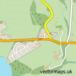
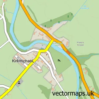
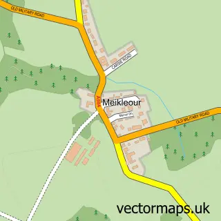
This Bridge of Cally street map is a detailed vector street map covering a 750m x 750m area. Select a larger area to create and download your own vector street map of Bridge of Cally.
The 750-metre map sample for Bridge of Cally covers 51 mapped buildings and approximately 16.1 km of road detail, of which 1 named road are named. The wider area around Bridge of Cally features 1 tourism point of interest, 1 hotel and 1 campsite within 2 miles. To create a larger or custom map of Bridge of Cally, the map builder lets you define your own coverage area and download editable SVG, PDF and PNG files.
Create a larger editable map of Bridge of Cally
Choose any area you need and generate a high-quality vector map instantly. Perfect for print, planning, design, business and personal use.

This Bridge of Cally street map in Perth and Kinross is available as downloadable SVG, PDF and PNG map files, or as a printed map for planning, business, display, education, local information and design work. You can also create a larger custom map area using the map selector.
What this Bridge of Cally map sample shows
Bridge of Cally lies within Perth And Kinross parish, part of Blairgowrie And Glens ward in the Perth And Kinross local authority area. The postcode geography for this area includes the PH postcode area, the PH10 postcode district and the PH10 7 postcode sector. Residents fall under the Tayside for NHS services.
Local features near Bridge of Cally
Within 2 milesAmenities and services in and around Bridge of Cally.
Administrative and postcode information for Bridge of Cally
The local authority covering Bridge of Cally is Perth And Kinross, within the county of Perth And Kinross. The settlement lies within Blairgowrie And Glens ward and Perth And Kinross civil parish. The PH10 postcode district and PH10 7 postcode sector serve the immediate area. NHS provision in the area is delivered through Tayside.
Nearby street map samples around Bridge of Cally

More street maps in Perth and Kinross
750 metre map area coverage
Boundary, postcode and point of interest information for the 750m x 750m rectangle centred on this sample map.
Boundaries containing map centre
Constituency: Angus and Perthshire Glens Co Const
District: Perth and Kinross
Icb: Tayside
Postcode District: PH10
Postcode Sector: PH10 7
Ward: Blairgowrie and Glens Ward
Nearby boundaries intersecting sample
No additional intersecting boundaries found.
Postcode coverage
POI category counts
Ski And Snowboard Shop: 2
Arts And Entertainment: 1
Bookstore: 1
Campground: 1
Farm: 1
Holiday Rental Home: 1
Hotel: 1
Resort: 1
Shipping Center: 1
Sample points of interest
- Bridge of Cally
- River Thoughtful Fishing Books
- Corriefodly Holiday Park
- Heather Hills Farm
- Balnabea Self Catering
- Bridge of Cally Hotel
- The Bridge Of Cally Hotel
- Bridge of Cally Post Office
- Bridge of Cally Ski Hire
- The Cabin Ski Hire
Create a larger editable map of Bridge of Cally
This sample shows only a 750 metre area. To create a larger map of Bridge of Cally, use our map builder to choose your own coverage area, add titles and download editable SVG, PDF and PNG files.
Create a custom map of Bridge of Cally