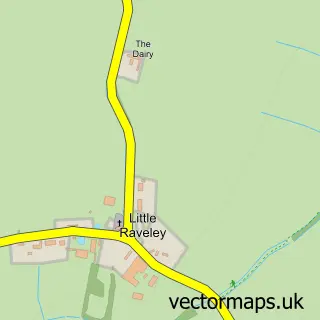
This Broughton street map is a detailed vector street map covering a 750m x 750m area. Select a larger area to create and download your own vector street map of Broughton.
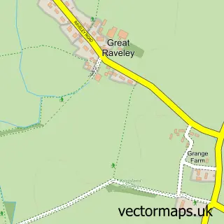
The 750-metre map sample for Broughton covers 127 mapped buildings and approximately 8.2 km of road detail, of which 6 named roads are named. The immediate area includes 1 GP surgery within 2 miles, 1 pub and 2 MOT stations within 2 miles. The wider area around Broughton features 1 food and drink venue. To create a larger or custom map of Broughton, the map builder lets you define your own coverage area and download editable SVG, PDF and PNG files.
Create a larger editable map of Broughton
Choose any area you need and generate a high-quality vector map instantly. Perfect for print, planning, design, business and personal use.

This Broughton street map in Cambridgeshire is available as downloadable SVG, PDF and PNG map files, or as a printed map for planning, business, display, education, local information and design work. You can also create a larger custom map area using the map selector.
What this Broughton map sample shows
Broughton lies within Broughton Cp parish, part of Warboys ward in the Huntingdonshire District local authority area. The postcode geography for this area includes the PE postcode area, the PE28 postcode district and the PE28 3 postcode sector. Residents fall under the Nhs Cambridgeshire And Peterborough Integrated Care Board for NHS services.
Local features near Broughton
Within 2 milesAmenities and services in and around Broughton.
Administrative and postcode information for Broughton
Broughton lies within Broughton Cp parish, part of Warboys ward in the Huntingdonshire District local authority area. The postcode geography for this area includes the PE postcode area, the PE28 postcode district and the PE28 3 postcode sector. Residents fall under the Nhs Cambridgeshire And Peterborough Integrated Care Board for NHS services.
Nearby street map samples around Broughton

More street maps in Cambridgeshire
750 metre map area coverage
Boundary, postcode and point of interest information for the 750m x 750m rectangle centred on this sample map.
Boundaries containing map centre
Constituency: Huntingdon Co Const
County: Cambridgeshire County
District: Huntingdonshire District
Icb: NHS Central East ICB
Parish: Broughton CP
Police Force: cambridgeshire
Postcode District: PE28
Postcode Sector: PE28 3
Ward: Warboys Ward
Nearby boundaries intersecting sample
No additional intersecting boundaries found.
Postcode coverage
POI category counts
Anglican Church: 1
Carpenter: 1
Cinema: 1
Dairy Stores: 1
Engineering Services: 1
Furniture Manufacturers: 1
Information Technology Company: 1
Legal Services: 1
Nursing School: 1
Pub: 1
Sample points of interest
- Broughton All Saints
- P R & A J Upshall Ltd.
- Lulu's Outdoor Picture Show
- Oliveolive
- Origin
- Imperial Design K B S O Ltd.
- Cambridge Networks
- Wills Jacobsen Legal
- Rose Cottage Care Home
- The Crown Inn
- Rose Cottage
Create a larger editable map of Broughton
This sample shows only a 750 metre area. To create a larger map of Broughton, use our map builder to choose your own coverage area, add titles and download editable SVG, PDF and PNG files.
Create a custom map of Broughton