Vector Maps logo
Home Why it works Popular maps Districts Samples Customizer Create Your Map
VectorMaps.uk
Home Popular maps Districts Samples Customizer Create Your Map Privacy Disclaimer
Home / UK Maps / Lanarkshire / Carnwath Map

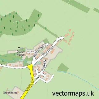
This Carnwath street map is a detailed vector street map covering a 750m x 750m area. Select a larger area to create and download your own vector street map of Carnwath.

Carnwath is a village in Lanarkshire, in the South Scotland of Scotland. The settlement falls within the Lanark And Hamilton East parliamentary constituency. It is served by the ML11 postcode district, with ML11 8 as the local postcode sector.

The 750-metre map sample for Carnwath covers 222 mapped buildings and approximately 9.4 km of road detail, of which 15 named roads are named. The immediate area includes 1 GP surgery and 1 MOT station. The wider area around Carnwath features 3 tourism points of interest, 1 food and drink venue and 1 hotel. To create a larger or custom map of Carnwath, the map builder lets you define your own coverage area and download editable SVG, PDF and PNG files.

222Buildings
9.42 kmRoads
15Named roads
0Residents within 2 miles
Create your own

Create a larger editable map of Carnwath

Choose any area you need and generate a high-quality vector map instantly. Perfect for print, planning, design, business and personal use.

Choose any location
Editable SVG files
Any size up to A0
PDF, PNG & more
Instant download
High quality guaranteed
Create My Custom Map
Secure, private & no credit card required
Carnwath Vector Street Map
750m Sample
Carnwath vector street map sample showing roads, buildings and local features in a 750 metre preview area
Buy Carnwath Map Print from £12.95 Buy Carnwath Digital Map from £6

This Carnwath street map in Lanarkshire is available as downloadable SVG, PDF and PNG map files, or as a printed map for planning, business, display, education, local information and design work. You can also create a larger custom map area using the map selector.

What this Carnwath map sample shows

Carnwath lies within South Lanarkshire parish, part of Clydesdale East ward in the South Lanarkshire local authority area. The postcode geography for this area includes the ML postcode area, the ML11 postcode district and the ML11 8 postcode sector. Residents fall under the Lanarkshire for NHS services.

Local features near Carnwath

Within 2 miles

Amenities and services in and around Carnwath.

1 GP surgeries 1 within 2 miles
1 MOT stations 1 within 2 miles
3 Tourism & leisure
1 Food & drink
1 Hotels
3 Healthcare POIs
3 Vehicle services

Counts are approximate and based on publicly available data.

Administrative and postcode information for Carnwath

The local authority covering Carnwath is South Lanarkshire, within the county of Lanarkshire. The settlement lies within Clydesdale East ward and South Lanarkshire civil parish. The ML11 postcode district and ML11 8 postcode sector serve the immediate area. NHS provision in the area is delivered through Lanarkshire.

Parish SOUTH LANARKSHIRE
Ward Clydesdale East
District / local authority South Lanarkshire
County Lanarkshire
Historic county Lanarkshire
Postcode district ML11
Postcode sector ML11 8
Parliamentary constituency Lanark and Hamilton East
Region South Scotland
Country Scotland

Nearby street map samples around Carnwath

Street map sample of Lanark, Lanarkshire Lanark Town - Lanarkshire - 6.2 miles Street map sample of Edinburgh, City of Edinburgh Edinburgh City - City of Edinburgh - 24.4 miles Street map sample of West End, Lanarkshire West End Village - Lanarkshire - 0.9 miles Street map sample of Kaimend, Lanarkshire Kaimend Village - Lanarkshire - 1.2 miles Street map sample of Carstairs Junction, Lanarkshire Carstairs Junction Village - Lanarkshire - 1.7 miles Street map sample of Bertram House, Lanarkshire Bertram House Village - Lanarkshire - 1.9 miles Street map sample of Libberton, Lanarkshire Libberton Village - Lanarkshire - 2.2 miles Street map sample of Newbigging, Lanarkshire Newbigging Village - Lanarkshire - 2.3 miles Street map sample of Carstairs, Lanarkshire Carstairs Village - Lanarkshire - 2.5 miles Street map sample of Pettinain, Lanarkshire Pettinain Village - Lanarkshire - 2.6 miles

More street maps in Lanarkshire

Street map sample of West End, Lanarkshire West End Village - 0.9 miles Street map sample of Kaimend, Lanarkshire Kaimend Village - 1.2 miles Street map sample of Carstairs Junction, Lanarkshire Carstairs Junction Village - 1.7 miles Street map sample of Bertram House, Lanarkshire Bertram House Village - 1.9 miles Street map sample of Libberton, Lanarkshire Libberton Village - 2.2 miles

750 metre map area coverage

Boundary, postcode and point of interest information for the 750m x 750m rectangle centred on this sample map.

Boundaries containing map centre

Constituency: Dumfriesshire, Clydesdale and Tweeddale Co Const

District: South Lanarkshire

Icb: Lanarkshire

Postcode District: ML11

Postcode Sector: ML11 8

Ward: Clydesdale East Ward

Nearby boundaries intersecting sample

No additional intersecting boundaries found.

Postcode coverage

ML11 ML11 8

POI category counts

Automotive Repair: 3

Park: 3

Bakery: 2

Bar: 2

Caterer: 2

Convenience Store: 2

Home Goods Store: 2

Indian Restaurant: 2

Interior Design: 2

Architect: 1

Sample points of interest

  • Architectural Design Solution Scot Architect
  • Neville Design Ltd Architectural Designer
  • The Craft Gallery Arts And Crafts
  • Kays Vehicle Services and Machine Shop Automotive Repair
  • Westend Garage Automotive Repair
  • Westend Garage Automotive Repair
  • Tartan pies Bakery
  • The Apple Pie Bakery
  • Masons Arms Bar
  • The Wee Bush Bar
  • Lil beaut by Rhona Beauty Salon
  • The Deli Carnwath Cafe

Create a larger editable map of Carnwath

This sample shows only a 750 metre area. To create a larger map of Carnwath, use our map builder to choose your own coverage area, add titles and download editable SVG, PDF and PNG files.

Create a custom map of Carnwath

Phone 01751 473136 | Copyright Vectormaps.uk 2026

Samples Customizer Privacy Disclaimer
Carnwath Vector Street Map
Carnwath enlarged street map sample showing a 750 metre preview area