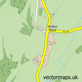
This Casterton street map is a detailed vector street map covering a 750m x 750m area. Select a larger area to create and download your own vector street map of Casterton.
The 750-metre map sample for Casterton covers 89 mapped buildings and approximately 8.7 km of road detail, of which 5 named roads are named. The immediate area includes 1 school, 1 GP surgery within 2 miles, 1 pub and 1 MOT station, with 3 within 2 miles. The wider area around Casterton features 1 tourism point of interest, 1 food and drink venue and 1 campsite within 2 miles. To create a larger or custom map of Casterton, the map builder lets you define your own coverage area and download editable SVG, PDF and PNG files.
Create a larger editable map of Casterton
Choose any area you need and generate a high-quality vector map instantly. Perfect for print, planning, design, business and personal use.

This Casterton street map in Cumbria is available as downloadable SVG, PDF and PNG map files, or as a printed map for planning, business, display, education, local information and design work. You can also create a larger custom map area using the map selector.
What this Casterton map sample shows
Casterton lies within Casterton Cp parish, part of Sedbergh & Kirkby Lonsdale ward in the Westmorland And Furness local authority area. The postcode geography for this area includes the LA postcode area, the LA6 postcode district and the LA6 2 postcode sector. Residents fall under the Nhs Lancashire And South Cumbria Integrated Care Board for NHS services.
Local features near Casterton
Within 2 milesAmenities and services in and around Casterton.
Administrative and postcode information for Casterton
The local authority covering Casterton is Westmorland And Furness, within the county of Cumbria. The settlement lies within Sedbergh & Kirkby Lonsdale ward and Casterton Cp civil parish. The LA6 postcode district and LA6 2 postcode sector serve the immediate area. NHS provision in the area is delivered through University Hospitals Of Morecambe Bay Nhs Foundation Trust.
Nearby street map samples around Casterton

More street maps in Cumbria
750 metre map area coverage
Boundary, postcode and point of interest information for the 750m x 750m rectangle centred on this sample map.
Boundaries containing map centre
Constituency: Morecambe and Lunesdale Co Const
District: Westmorland and Furness
Icb: NHS Lancashire and South Cumbria ICB
Parish: Casterton CP
Police Force: cumbria
Postcode District: LA6
Postcode Sector: LA6 2
Ward: Sedbergh and Kirkby Lonsdale Ward
Nearby boundaries intersecting sample
No additional intersecting boundaries found.
Postcode coverage
POI category counts
Automotive Repair: 1
Church Cathedral: 1
Cottage: 1
Holiday Rental Home: 1
Landmark And Historical Building: 1
Preschool: 1
Private School: 1
Pub: 1
Sample points of interest
- Town End Garage
- Holy Trinity Church
- Garner Cottage - Nr Kirkby Lonsdale
- Bronte House Apartment
- Casterton
- The Mulberry Bush Nursery
- Casterton Sedbergh Preparatory School
- The Pheasant Inn
Create a larger editable map of Casterton
This sample shows only a 750 metre area. To create a larger map of Casterton, use our map builder to choose your own coverage area, add titles and download editable SVG, PDF and PNG files.
Create a custom map of Casterton