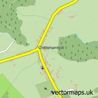
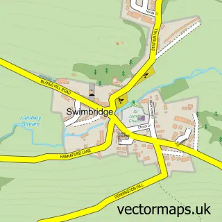
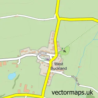
This Chittlehampton street map is a detailed vector street map covering a 750m x 750m area. Select a larger area to create and download your own vector street map of Chittlehampton.
The 750-metre map sample for Chittlehampton covers 127 mapped buildings and approximately 6.4 km of road detail, of which 7 named roads are named. The immediate area includes 1 pub. The wider area around Chittlehampton features 1 food and drink venue and 1 campsite within 2 miles. To create a larger or custom map of Chittlehampton, the map builder lets you define your own coverage area and download editable SVG, PDF and PNG files.
Create a larger editable map of Chittlehampton
Choose any area you need and generate a high-quality vector map instantly. Perfect for print, planning, design, business and personal use.

This Chittlehampton street map in Devon is available as downloadable SVG, PDF and PNG map files, or as a printed map for planning, business, display, education, local information and design work. You can also create a larger custom map area using the map selector.
What this Chittlehampton map sample shows
Chittlehampton lies within Chittlehampton Cp parish, part of Chittlehampton ward in the North Devon District local authority area. The postcode geography for this area includes the EX postcode area, the EX37 postcode district and the EX37 9 postcode sector. Residents fall under the Nhs Devon Integrated Care Board for NHS services.
Local features near Chittlehampton
Within 2 milesAmenities and services in and around Chittlehampton.
Administrative and postcode information for Chittlehampton
Chittlehampton lies within Chittlehampton Cp parish, part of Chittlehampton ward in the North Devon District local authority area. The postcode geography for this area includes the EX postcode area, the EX37 postcode district and the EX37 9 postcode sector. Residents fall under the Nhs Devon Integrated Care Board for NHS services.
Nearby street map samples around Chittlehampton

More street maps in Devon
750 metre map area coverage
Boundary, postcode and point of interest information for the 750m x 750m rectangle centred on this sample map.
Boundaries containing map centre
Constituency: North Devon Co Const
County: Devon County
District: North Devon District
Icb: NHS Devon ICB
Parish: Chittlehampton CP
Police Force: devon and cornwall
Postcode District: EX37
Postcode Sector: EX37 9
Ward: Chittlehampton Ward
Nearby boundaries intersecting sample
No additional intersecting boundaries found.
Postcode coverage
POI category counts
Building Supply Store: 2
Anglican Church: 1
Bar: 1
Church Cathedral: 1
Convenience Store: 1
Elementary School: 1
Home Decor: 1
Post Office: 1
Pub: 1
Self Catering Accommodation: 1
Sample points of interest
- St Hieritha
- North Devon Outside Bars
- Mark Berry Plumbing & Heating
- Window Cleaning Services North Devon
- North Molton Methodist Church
- Chittlehampton Village Shop
- Chittlehampton Church of England Primary School
- Roger Cockram Ceramics Ltd.
- Post Office
- The Bell Inn Chittlehampton
- Prospect Cottage
- Webworld-UK
Create a larger editable map of Chittlehampton
This sample shows only a 750 metre area. To create a larger map of Chittlehampton, use our map builder to choose your own coverage area, add titles and download editable SVG, PDF and PNG files.
Create a custom map of Chittlehampton