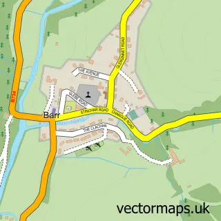
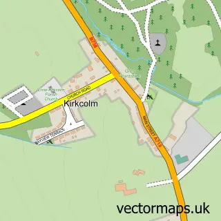
This Colmonell street map is a detailed vector street map covering a 750m x 750m area. Select a larger area to create and download your own vector street map of Colmonell.
The 750-metre map sample for Colmonell covers 98 mapped buildings and approximately 7.6 km of road detail, of which 8 named roads are named. The wider area around Colmonell features 2 tourism points of interest and 2 hotels. To create a larger or custom map of Colmonell, the map builder lets you define your own coverage area and download editable SVG, PDF and PNG files.
Create a larger editable map of Colmonell
Choose any area you need and generate a high-quality vector map instantly. Perfect for print, planning, design, business and personal use.

This Colmonell street map in Ayrshire and Arran is available as downloadable SVG, PDF and PNG map files, or as a printed map for planning, business, display, education, local information and design work. You can also create a larger custom map area using the map selector.
What this Colmonell map sample shows
Colmonell lies within South Ayrshire parish, part of Girvan And South Carrick ward in the South Ayrshire local authority area. The postcode geography for this area includes the KA postcode area, the KA26 postcode district and the KA26 0 postcode sector. Residents fall under the Ayrshire And Arran for NHS services.
Local features near Colmonell
Within 2 milesAmenities and services in and around Colmonell.
Administrative and postcode information for Colmonell
The local authority covering Colmonell is South Ayrshire, within the county of Ayrshire And Arran. The settlement lies within Girvan And South Carrick ward and South Ayrshire civil parish. The KA26 postcode district and KA26 0 postcode sector serve the immediate area. NHS provision in the area is delivered through Ayrshire And Arran.
Nearby street map samples around Colmonell

More street maps in Ayrshire and Arran
750 metre map area coverage
Boundary, postcode and point of interest information for the 750m x 750m rectangle centred on this sample map.
Boundaries containing map centre
Constituency: Ayr, Carrick and Cumnock Co Const
District: South Ayrshire
Icb: Ayrshire and Arran
Postcode District: KA26
Postcode Sector: KA26 0
Ward: Girvan and South Carrick Ward
Nearby boundaries intersecting sample
No additional intersecting boundaries found.
Postcode coverage
POI category counts
Clothing Store: 3
Hotel: 2
Catholic Church: 1
Community Center: 1
Cottage: 1
Elementary School: 1
Landmark And Historical Building: 1
Lumber Store: 1
Park: 1
Youth Organizations: 1
Sample points of interest
- St Colmon Parish Church
- PPG Workwear
- PPG Workwear
- The Rantin Robin
- Colmonell Community Centre
- Stinchar Cottages
- Colmonell Primary School
- Boars Head Hotel
- The Cottage at 59
- Colmonell
- J & W Dunlop
- Strathavon Caravan Park
Create a larger editable map of Colmonell
This sample shows only a 750 metre area. To create a larger map of Colmonell, use our map builder to choose your own coverage area, add titles and download editable SVG, PDF and PNG files.
Create a custom map of Colmonell