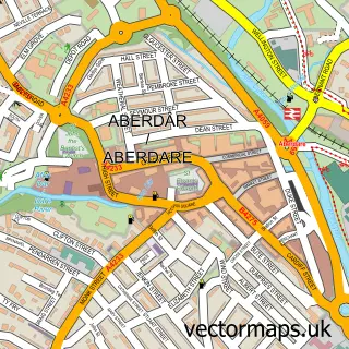
This Cwmaman street map is a detailed vector street map covering a 750m x 750m area. Select a larger area to create and download your own vector street map of Cwmaman.
The 750-metre map sample for Cwmaman covers 170 mapped buildings and approximately 12.6 km of road detail, of which 19 named roads are named. The immediate area includes 2 GP surgeries within 2 miles and 8 MOT stations within 2 miles. The wider area around Cwmaman features 1 food and drink venue and 1 hotel. To create a larger or custom map of Cwmaman, the map builder lets you define your own coverage area and download editable SVG, PDF and PNG files.
Create a larger editable map of Cwmaman
Choose any area you need and generate a high-quality vector map instantly. Perfect for print, planning, design, business and personal use.

This Cwmaman street map in Mid Glamorgan is available as downloadable SVG, PDF and PNG map files, or as a printed map for planning, business, display, education, local information and design work. You can also create a larger custom map area using the map selector.
What this Cwmaman map sample shows
Cwmaman lies within Aberaman South Community parish, part of Aberaman South ward in the Rhondda Cynon Taf - Rhondda Cynon Taf local authority area. The postcode geography for this area includes the CF postcode area, the CF44 postcode district and the CF44 6 postcode sector. Residents fall under the Cwm Taf University Health Board for NHS services.
Local features near Cwmaman
Within 2 milesAmenities and services in and around Cwmaman.
Administrative and postcode information for Cwmaman
The local authority covering Cwmaman is Rhondda Cynon Taf - Rhondda Cynon Taf, within the county of Mid Glamorgan. The settlement lies within Aberaman South ward and Aberaman South Community civil parish. The CF44 postcode district and CF44 6 postcode sector serve the immediate area. NHS provision in the area is delivered through Cwm Taf Morgannwg University Health Board.
Nearby street map samples around Cwmaman

More street maps in Mid Glamorgan
750 metre map area coverage
Boundary, postcode and point of interest information for the 750m x 750m rectangle centred on this sample map.
Boundaries containing map centre
Constituency: Merthyr Tydfil and Aberdare Co Const
District: Rhondda Cynon Taf - Rhondda Cynon Taf
Icb: Cwm Taf University
Parish: Aberaman South Community
Police Force: south wales
Postcode District: CF44
Postcode Sector: CF44 6
Nearby boundaries intersecting sample
Parish: Aberaman North Community
Postcode coverage
POI category counts
Church Cathedral: 3
Electrician: 2
Assisted Living Facility: 1
Cafe: 1
Drugstore: 1
Elementary School: 1
Gym: 1
Hair Salon: 1
High School: 1
Hotel: 1
Sample points of interest
- Cwmaman Care Centre
- Queen Ti's
- Hope Church
- St Joseph's Church
- St. Joseph's Environmental and Heritage Centre
- S R Bailey
- OFC Electrics
- OFC Electrics
- Cwmaman Primary School
- Commando Fit
- Julies Hair Salon
- Glynhafod Junior School
Create a larger editable map of Cwmaman
This sample shows only a 750 metre area. To create a larger map of Cwmaman, use our map builder to choose your own coverage area, add titles and download editable SVG, PDF and PNG files.
Create a custom map of Cwmaman