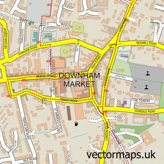
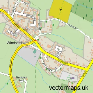
This Denver street map is a detailed vector street map covering a 750m x 750m area. Select a larger area to create and download your own vector street map of Denver.
The 750-metre map sample for Denver covers 247 mapped buildings and approximately 10.5 km of road detail, of which 10 named roads are named. The immediate area includes 1 school, 3 GP surgeries within 2 miles and 6 MOT stations within 2 miles. The wider area around Denver features 1 tourism point of interest, 1 food and drink venue and 1 hotel. To create a larger or custom map of Denver, the map builder lets you define your own coverage area and download editable SVG, PDF and PNG files.
Create a larger editable map of Denver
Choose any area you need and generate a high-quality vector map instantly. Perfect for print, planning, design, business and personal use.

This Denver street map in Norfolk is available as downloadable SVG, PDF and PNG map files, or as a printed map for planning, business, display, education, local information and design work. You can also create a larger custom map area using the map selector.
What this Denver map sample shows
Denver lies within Denver Cp parish, part of Denver ward in the King's Lynn And West Norfolk District (B) local authority area. The postcode geography for this area includes the PE postcode area, the PE38 postcode district and the PE38 0 postcode sector. Residents fall under the Nhs Norfolk And Waveney Integrated Care Board for NHS services.
Local features near Denver
Within 2 milesAmenities and services in and around Denver.
Administrative and postcode information for Denver
Denver lies within Denver Cp parish, part of Denver ward in the King's Lynn And West Norfolk District (B) local authority area. The postcode geography for this area includes the PE postcode area, the PE38 postcode district and the PE38 0 postcode sector. Residents fall under the Nhs Norfolk And Waveney Integrated Care Board for NHS services.
Nearby street map samples around Denver


More street maps in Norfolk
750 metre map area coverage
Boundary, postcode and point of interest information for the 750m x 750m rectangle centred on this sample map.
Boundaries containing map centre
Constituency: South West Norfolk Co Const
County: Norfolk County
District: King's Lynn and West Norfolk District (B)
Icb: NHS Norfolk and Waveney ICB
Parish: Denver CP
Police Force: norfolk
Postcode District: PE38
Postcode Sector: PE38 0
Ward: Denver Ward
Nearby boundaries intersecting sample
No additional intersecting boundaries found.
Postcode coverage
POI category counts
Elementary School: 2
Forestry Service: 2
Anglican Church: 1
Animal Shelter: 1
Attractions And Activities: 1
Audio Visual Equipment Store: 1
Bed And Breakfast: 1
Church Cathedral: 1
Community Center: 1
Contractor: 1
Sample points of interest
- St Mary's Church, Denver
- Brambles Animal Sanctuary
- Denver Playing Field and Cricket Pitch
- J.R Light & Sound
- BELLE VUE Guest House & Cottage Denver Village
- Denver Parish Church of St Mary
- Denver Village Hall
- PKS Construction
- Interstellar Events
- Post Office Travel Money
- Denver Primary School
- Denver Voluntary Controlled Primary School
Create a larger editable map of Denver
This sample shows only a 750 metre area. To create a larger map of Denver, use our map builder to choose your own coverage area, add titles and download editable SVG, PDF and PNG files.
Create a custom map of Denver