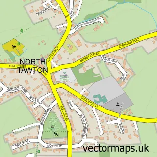
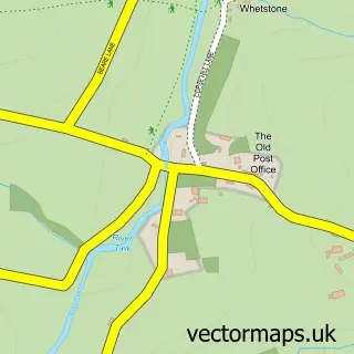
This Exbourne street map is a detailed vector street map covering a 750m x 750m area. Select a larger area to create and download your own vector street map of Exbourne.
The 750-metre map sample for Exbourne covers 158 mapped buildings and approximately 13.4 km of road detail, of which 10 named roads are named. The immediate area includes 1 school, 1 pub and 1 MOT station. The wider area around Exbourne features 2 food and drink venues. To create a larger or custom map of Exbourne, the map builder lets you define your own coverage area and download editable SVG, PDF and PNG files.
Create a larger editable map of Exbourne
Choose any area you need and generate a high-quality vector map instantly. Perfect for print, planning, design, business and personal use.

This Exbourne street map in Devon is available as downloadable SVG, PDF and PNG map files, or as a printed map for planning, business, display, education, local information and design work. You can also create a larger custom map area using the map selector.
What this Exbourne map sample shows
Exbourne lies within Exbourne Cp parish, part of Exbourne ward in the West Devon District (B) local authority area. The postcode geography for this area includes the EX postcode area, the EX20 postcode district and the EX20 3 postcode sector. Residents fall under the Nhs Devon Integrated Care Board for NHS services.
Local features near Exbourne
Within 2 milesAmenities and services in and around Exbourne.
Administrative and postcode information for Exbourne
Exbourne lies within Exbourne Cp parish, part of Exbourne ward in the West Devon District (B) local authority area. The postcode geography for this area includes the EX postcode area, the EX20 postcode district and the EX20 3 postcode sector. Residents fall under the Nhs Devon Integrated Care Board for NHS services.
Nearby street map samples around Exbourne

More street maps in Devon
750 metre map area coverage
Boundary, postcode and point of interest information for the 750m x 750m rectangle centred on this sample map.
Boundaries containing map centre
Constituency: Central Devon Co Const
County: Devon County
District: West Devon District (B)
Icb: NHS Devon ICB
Parish: Exbourne CP
Police Force: devon and cornwall
Postcode District: EX20
Postcode Sector: EX20 3
Ward: Exbourne Ward
Nearby boundaries intersecting sample
No additional intersecting boundaries found.
Postcode coverage
POI category counts
Acupuncture: 1
Anglican Church: 1
Automotive Repair: 1
Beverage Store: 1
Cafe: 1
Candy Store: 1
Hardware Store: 1
Nursery And Gardening: 1
Post Office: 1
Preschool: 1
Sample points of interest
- Wellspring
- St Mary Blessed Virgin
- Exbourne Cross Garage
- The Burrow
- The Burrow
- Sugar Rush Confectionery
- D H Services
- DH Services
- Post Office-Belstone
- Exbourne Pre-School
- The Red Lion Exbourne
- Exbourne Post Office
Create a larger editable map of Exbourne
This sample shows only a 750 metre area. To create a larger map of Exbourne, use our map builder to choose your own coverage area, add titles and download editable SVG, PDF and PNG files.
Create a custom map of Exbourne