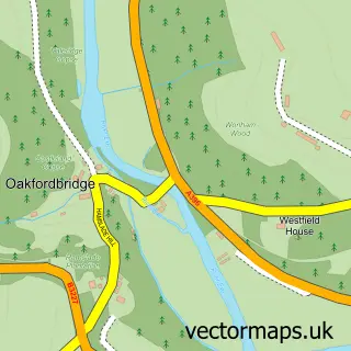
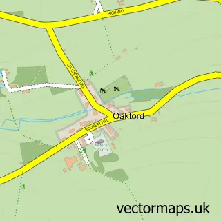
This Exebridge street map is a detailed vector street map covering a 750m x 750m area. Select a larger area to create and download your own vector street map of Exebridge.
The 750-metre map sample for Exebridge covers 66 mapped buildings and approximately 7.4 km of road detail. The immediate area includes 1 pub and 1 MOT station within 2 miles. The wider area around Exebridge features 2 tourism points of interest, 1 food and drink venue and 1 campsite within 2 miles. To create a larger or custom map of Exebridge, the map builder lets you define your own coverage area and download editable SVG, PDF and PNG files.
Create a larger editable map of Exebridge
Choose any area you need and generate a high-quality vector map instantly. Perfect for print, planning, design, business and personal use.

This Exebridge street map in Somerset is available as downloadable SVG, PDF and PNG map files, or as a printed map for planning, business, display, education, local information and design work. You can also create a larger custom map area using the map selector.
What this Exebridge map sample shows
Exebridge lies within Bampton Cp parish, part of Clare And Shuttern ward in the Mid Devon District local authority area. The postcode geography for this area includes the TA postcode area, the TA22 postcode district and the TA22 9 postcode sector. Residents fall under the Nhs Devon Integrated Care Board for NHS services.
Local features near Exebridge
Within 2 milesAmenities and services in and around Exebridge.
Administrative and postcode information for Exebridge
Exebridge lies within Bampton Cp parish, part of Clare And Shuttern ward in the Mid Devon District local authority area. The postcode geography for this area includes the TA postcode area, the TA22 postcode district and the TA22 9 postcode sector. Residents fall under the Nhs Devon Integrated Care Board for NHS services.
Nearby street map samples around Exebridge

More street maps in Somerset
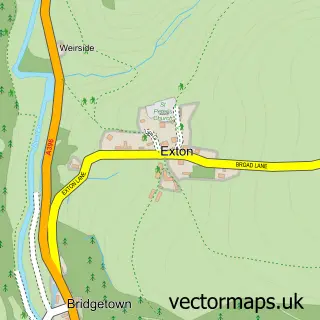
750 metre map area coverage
Boundary, postcode and point of interest information for the 750m x 750m rectangle centred on this sample map.
Boundaries containing map centre
Constituency: Tiverton and Minehead Co Const
District: Somerset
Icb: NHS Somerset ICB
Parish: Brushford CP
Police Force: avon and somerset
Postcode District: TA22
Postcode Sector: TA22 9
Nearby boundaries intersecting sample
County: Devon County
District: Mid Devon District
Icb: NHS Devon ICB
Parish: Bampton CP, Morebath CP
Police Force: devon and cornwall
Ward: Clare & Shuttern Ward
Postcode coverage
POI category counts
Banks: 1
Campground: 1
Landmark And Historical Building: 1
Lodge: 1
Pub: 1
Sporting Goods: 1
Sample points of interest
- NatWest
- Caravan Club
- Exebridge
- Lakeside Lodges
- The Anchor Inn
- Exe Valley Fly Fishing
Create a larger editable map of Exebridge
This sample shows only a 750 metre area. To create a larger map of Exebridge, use our map builder to choose your own coverage area, add titles and download editable SVG, PDF and PNG files.
Create a custom map of Exebridge