Vector Maps logo
Home Why it works Popular maps Districts Samples Customizer Create Your Map
VectorMaps.uk
Home Popular maps Districts Samples Customizer Create Your Map Privacy Disclaimer
Home / UK Maps / Northamptonshire / Farthinghoe Map

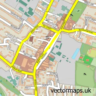
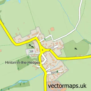
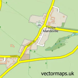
This Farthinghoe street map is a detailed vector street map covering a 750m x 750m area. Select a larger area to create and download your own vector street map of Farthinghoe.

Farthinghoe is a village in Northamptonshire, in the East Midlands of England. The settlement falls within the South Northamptonshire parliamentary constituency. It is served by the NN13 postcode district, with NN13 5 as the local postcode sector.

The 750-metre map sample for Farthinghoe covers 136 mapped buildings and approximately 20.9 km of road detail, of which 12 named roads are named. The immediate area includes 1 school, 2 pubs and 1 MOT station. The wider area around Farthinghoe features 1 tourism point of interest and 2 food and drink venues. To create a larger or custom map of Farthinghoe, the map builder lets you define your own coverage area and download editable SVG, PDF and PNG files.

136Buildings
20.87 kmRoads
12Named roads
459Residents within 2 miles
Create your own

Create a larger editable map of Farthinghoe

Choose any area you need and generate a high-quality vector map instantly. Perfect for print, planning, design, business and personal use.

Choose any location
Editable SVG files
Any size up to A0
PDF, PNG & more
Instant download
High quality guaranteed
Create My Custom Map
Secure, private & no credit card required
Farthinghoe Vector Street Map
750m Sample
Farthinghoe vector street map sample showing roads, buildings and local features in a 750 metre preview area
Buy Farthinghoe Map Print from £12.95 Buy Farthinghoe Digital Map from £6

This Farthinghoe street map in Northamptonshire is available as downloadable SVG, PDF and PNG map files, or as a printed map for planning, business, display, education, local information and design work. You can also create a larger custom map area using the map selector.

What this Farthinghoe map sample shows

Farthinghoe lies within Farthinghoe Cp parish, part of Steane ward in the West Northamptonshire local authority area. The postcode geography for this area includes the NN postcode area, the NN13 postcode district and the NN13 5 postcode sector. Residents fall under the Nhs Northamptonshire Integrated Care Board for NHS services.

Local features near Farthinghoe

Within 2 miles

Amenities and services in and around Farthinghoe.

1 Schools
1 MOT stations 1 within 2 miles
1 Tourism & leisure
2 Food & drink
2 Pubs

Counts are approximate and based on publicly available data.

Administrative and postcode information for Farthinghoe

The local authority covering Farthinghoe is West Northamptonshire, within the county of Northamptonshire. The settlement lies within Steane ward and Farthinghoe Cp civil parish. The NN13 postcode district and NN13 5 postcode sector serve the immediate area. NHS provision in the area is delivered through Oxford University Hospitals Nhs Foundation Trust.

Parish Farthinghoe CP
Ward Steane
District / local authority West Northamptonshire
County Northamptonshire
Historic county Northamptonshire
Postcode district NN13
Postcode sector NN13 5
Parliamentary constituency South Northamptonshire
Region East Midlands
Country England

Nearby street map samples around Farthinghoe

Street map sample of Brackley, Northamptonshire Brackley Town - Northamptonshire - 3.5 miles Street map sample of Milton Keynes, Buckinghamshire Milton Keynes City - Buckinghamshire - 19.6 miles Street map sample of Marston St. Lawrence, Northamptonshire Marston St. Lawrence Village - Northamptonshire - 1.6 miles Street map sample of Halse, Northamptonshire Halse Village - Northamptonshire - 2.0 miles Street map sample of Greatworth, Northamptonshire Greatworth Village - Northamptonshire - 2.0 miles Street map sample of Hinton-in-the-Hedges, Northamptonshire Hinton-in-the-Hedges Village - Northamptonshire - 2.2 miles Street map sample of Charlton, Northamptonshire Charlton Village - Northamptonshire - 2.3 miles Street map sample of Middleton Cheney, Northamptonshire Middleton Cheney Village - Northamptonshire - 2.7 miles Street map sample of Kings Sutton, Northamptonshire Kings Sutton Village - Northamptonshire - 3.1 miles Street map sample of Thorpe Mandeville, Northamptonshire Thorpe Mandeville Village - Northamptonshire - 3.2 miles

More street maps in Northamptonshire

Street map sample of Marston St. Lawrence, Northamptonshire Marston St. Lawrence Village - 1.6 miles Street map sample of Halse, Northamptonshire Halse Village - 2.0 miles Street map sample of Greatworth, Northamptonshire Greatworth Village - 2.0 miles Street map sample of Hinton-in-the-Hedges, Northamptonshire Hinton-in-the-Hedges Village - 2.2 miles Street map sample of Charlton, Northamptonshire Charlton Village - 2.3 miles

750 metre map area coverage

Boundary, postcode and point of interest information for the 750m x 750m rectangle centred on this sample map.

Boundaries containing map centre

Constituency: South Northamptonshire Co Const

District: West Northamptonshire

Icb: NHS Northamptonshire ICB

Parish: Farthinghoe CP

Police Force: northamptonshire

Postcode District: NN13

Postcode Sector: NN13 5

Ward: Middleton Cheney Ward

Nearby boundaries intersecting sample

No additional intersecting boundaries found.

Postcode coverage

NN13 NN13 5

POI category counts

Farm: 2

Pub: 2

Advertising Agency: 1

Anglican Church: 1

Building Supply Store: 1

Business Management Services: 1

Caterer: 1

Chiropractor: 1

Community Center: 1

It Service And Computer Repair: 1

Sample points of interest

  • DNA Design Consultants Advertising Agency
  • St Michael & All Angels Farthinghoe Anglican Church
  • Cars Company Building Supply Store
  • ITS Incognito Business Management Services
  • Indievictual Caterer
  • Marc Muncila Chiropractor
  • Farthinghoe Village Hall Community Center
  • Glebe Farm Farthinghoe Farm
  • Limes Farm Farm
  • Software Resource Manning It Service And Computer Repair
  • Farthinghoe Landmark And Historical Building
  • Farthinghoe Fine Wine Liquor Store

Create a larger editable map of Farthinghoe

This sample shows only a 750 metre area. To create a larger map of Farthinghoe, use our map builder to choose your own coverage area, add titles and download editable SVG, PDF and PNG files.

Create a custom map of Farthinghoe

Phone 01751 473136 | Copyright Vectormaps.uk 2026

Samples Customizer Privacy Disclaimer
Farthinghoe Vector Street Map
Farthinghoe enlarged street map sample showing a 750 metre preview area