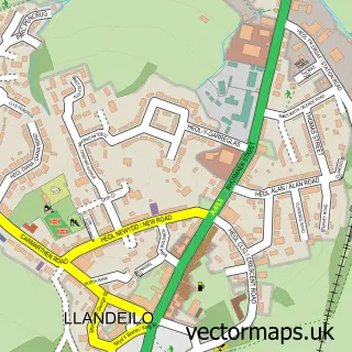
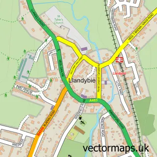
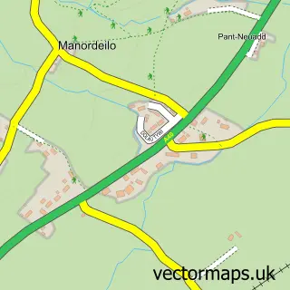
This Ffairfach street map is a detailed vector street map covering a 750m x 750m area. Select a larger area to create and download your own vector street map of Ffairfach.
The 750-metre map sample for Ffairfach covers 147 mapped buildings and approximately 8.6 km of road detail, of which 6 named roads are named. The immediate area includes 1 school, 1 railway station and 1 pub. The wider area around Ffairfach features 1 tourism point of interest and 3 food and drink venues. To create a larger or custom map of Ffairfach, the map builder lets you define your own coverage area and download editable SVG, PDF and PNG files.
Create a larger editable map of Ffairfach
Choose any area you need and generate a high-quality vector map instantly. Perfect for print, planning, design, business and personal use.

This Ffairfach street map in Dyfed is available as downloadable SVG, PDF and PNG map files, or as a printed map for planning, business, display, education, local information and design work. You can also create a larger custom map area using the map selector.
What this Ffairfach map sample shows
Ffairfach lies within Cyngor Bro Dyffryn Cennen Community parish, part of Llandeilo ward in the Sir Gaerfyrddin - Carmarthenshire local authority area. The postcode geography for this area includes the SA postcode area, the SA19 postcode district and the SA19 6 postcode sector. Residents fall under the Hywel Dda University Health Board for NHS services.
Local features near Ffairfach
Within 2 milesAmenities and services in and around Ffairfach.
Administrative and postcode information for Ffairfach
Ffairfach lies within Cyngor Bro Dyffryn Cennen Community parish, part of Llandeilo ward in the Sir Gaerfyrddin - Carmarthenshire local authority area. The postcode geography for this area includes the SA postcode area, the SA19 postcode district and the SA19 6 postcode sector. Residents fall under the Hywel Dda University Health Board for NHS services.
Nearby street map samples around Ffairfach

More street maps in Dyfed
750 metre map area coverage
Boundary, postcode and point of interest information for the 750m x 750m rectangle centred on this sample map.
Boundaries containing map centre
Constituency: Caerfyrddin Co Const
District: Sir Gaerfyrddin - Carmarthenshire
Icb: Hywel Dda
Parish: Cyngor Bro Dyffryn Cennen Community
Police Force: dyfed-powys
Postcode District: SA19
Postcode Sector: SA19 6
Nearby boundaries intersecting sample
Parish: Llandeilo Community
Postcode coverage
POI category counts
Butcher Shop: 2
Hvac Services: 2
Restaurant: 2
Train Station: 2
Agriculture: 1
Amusement Park: 1
Bed And Breakfast: 1
Cupcake Shop: 1
Dog Walkers: 1
Elementary School: 1
Sample points of interest
- Wynnstay Stores
- Andrew Holmes Fun Fairs
- Melin Tregib
- Dewi Roberts Family Butchers
- Dewi Roberts Family Butchers
- Flows at Ffairfach
- Teilotails
- Ysgol Gynradd Ffairfach
- Wynnstay Llandeilo
- Tregib Mill Self Catering Cottage
- George Rowan Chimneys & Stoves
- Towy Valley Heating Ltd
Create a larger editable map of Ffairfach
This sample shows only a 750 metre area. To create a larger map of Ffairfach, use our map builder to choose your own coverage area, add titles and download editable SVG, PDF and PNG files.
Create a custom map of Ffairfach