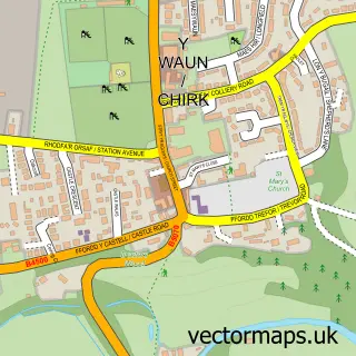
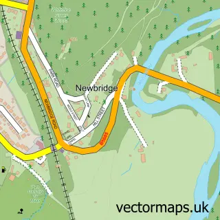
This Froncysyllte street map is a detailed vector street map covering a 750m x 750m area. Select a larger area to create and download your own vector street map of Froncysyllte.
The 750-metre map sample for Froncysyllte covers 203 mapped buildings and approximately 17.3 km of road detail, of which 10 named roads are named. The immediate area includes 1 GP surgery within 2 miles, 1 pub and 1 MOT station, with 4 within 2 miles. The wider area around Froncysyllte features 1 tourism point of interest, 4 food and drink venues and 1 hotel. To create a larger or custom map of Froncysyllte, the map builder lets you define your own coverage area and download editable SVG, PDF and PNG files.
Create a larger editable map of Froncysyllte
Choose any area you need and generate a high-quality vector map instantly. Perfect for print, planning, design, business and personal use.

This Froncysyllte street map in Clwyd is available as downloadable SVG, PDF and PNG map files, or as a printed map for planning, business, display, education, local information and design work. You can also create a larger custom map area using the map selector.
What this Froncysyllte map sample shows
Froncysyllte lies within Llangollen Rural Community parish, part of Llangollen Rural ward in the Wrecsam - Wrexham local authority area. The postcode geography for this area includes the LL postcode area, the LL20 postcode district and the LL20 7 postcode sector. Residents fall under the Betsi Cadwaladr University Health Board for NHS services.
Local features near Froncysyllte
Within 2 milesAmenities and services in and around Froncysyllte.
Administrative and postcode information for Froncysyllte
The local authority covering Froncysyllte is Wrecsam - Wrexham, within the county of Clwyd. The settlement lies within Llangollen Rural ward and Llangollen Rural Community civil parish. The LL20 postcode district and LL20 7 postcode sector serve the immediate area. NHS provision in the area is delivered through Betsi Cadwaladr University Health Board.
Nearby street map samples around Froncysyllte


More street maps in Clwyd
750 metre map area coverage
Boundary, postcode and point of interest information for the 750m x 750m rectangle centred on this sample map.
Boundaries containing map centre
Constituency: Clwyd East Co Const
District: Wrecsam - Wrexham
Icb: Betsi Cadwaladr University
Parish: Llangollen Rural Community
Police Force: north wales
Postcode District: LL20
Postcode Sector: LL20 7
Nearby boundaries intersecting sample
Constituency: Montgomeryshire and Glyndwr Co Const
Parish: Chirk Community
Postcode District: LL14
Postcode Sector: LL14 5
Postcode coverage
POI category counts
Cafe: 2
Auction House: 1
Automotive Repair: 1
Beauty Salon: 1
Bed And Breakfast: 1
Diner: 1
Dog Trainer: 1
Elementary School: 1
Hotel: 1
Junkyard: 1
Sample points of interest
- Cooper Barrington LLP
- A N Richards Ltd
- The Laser Therapy Company
- Nesscliffe B&B
- Sian's Cafe in the Garden
- The Limekilns Cafe & Caterers
- Aqueduct Diner
- Beastly Thoughts Professional Dog Services
- Froncysyllte County Primary School
- Argoed Farm
- Beavers Alley
- Llangollen, North Wales
Create a larger editable map of Froncysyllte
This sample shows only a 750 metre area. To create a larger map of Froncysyllte, use our map builder to choose your own coverage area, add titles and download editable SVG, PDF and PNG files.
Create a custom map of Froncysyllte