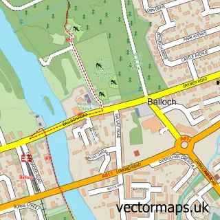
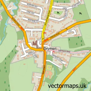
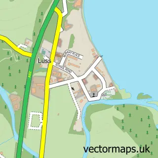
This Gartocharn street map is a detailed vector street map covering a 750m x 750m area. Select a larger area to create and download your own vector street map of Gartocharn.
The 750-metre map sample for Gartocharn covers 123 mapped buildings and approximately 9.9 km of road detail, of which 4 named roads are named. The wider area around Gartocharn features 1 food and drink venue and 3 hotels. To create a larger or custom map of Gartocharn, the map builder lets you define your own coverage area and download editable SVG, PDF and PNG files.
Create a larger editable map of Gartocharn
Choose any area you need and generate a high-quality vector map instantly. Perfect for print, planning, design, business and personal use.

This Gartocharn street map in Dunbartonshire is available as downloadable SVG, PDF and PNG map files, or as a printed map for planning, business, display, education, local information and design work. You can also create a larger custom map area using the map selector.
What this Gartocharn map sample shows
Gartocharn lies within West Dunbartonshire parish, part of Lomond ward in the West Dunbartonshire local authority area. The postcode geography for this area includes the G postcode area, the G83 postcode district and the G83 8 postcode sector. Residents fall under the Greater Glasgow And Clyde for NHS services.
Local features near Gartocharn
Within 2 milesAmenities and services in and around Gartocharn.
Administrative and postcode information for Gartocharn
Gartocharn lies within West Dunbartonshire parish, part of Lomond ward in the West Dunbartonshire local authority area. The postcode geography for this area includes the G postcode area, the G83 postcode district and the G83 8 postcode sector. Residents fall under the Greater Glasgow And Clyde for NHS services.
Nearby street map samples around Gartocharn

More street maps in Dunbartonshire
750 metre map area coverage
Boundary, postcode and point of interest information for the 750m x 750m rectangle centred on this sample map.
Boundaries containing map centre
Constituency: West Dunbartonshire Co Const
District: West Dunbartonshire
Icb: Greater Glasgow and Clyde
Postcode District: G83
Postcode Sector: G83 8
Ward: Lomond Ward
Nearby boundaries intersecting sample
No additional intersecting boundaries found.
Postcode coverage
POI category counts
Hotel: 3
Community Center: 2
Automotive Repair: 1
Building Contractor: 1
Bus Service: 1
Catholic Church: 1
Coffee Shop: 1
Elementary School: 1
Farm: 1
Holiday Rental Home: 1
Sample points of interest
- Lomond View Garage
- Lomond Building Consultants
- Carrs Loch Lomond
- Lomond
- House of Darrach, Gartocharn
- Kilmaronock Millennium Hall
- Millennium Hall Gartoharn
- Gartocharn Primary School
- France Farm
- East Cambusmoon Holiday Cottages
- Kilmaronock Manse Bed and Breakfast
- St Ronan's Place
Create a larger editable map of Gartocharn
This sample shows only a 750 metre area. To create a larger map of Gartocharn, use our map builder to choose your own coverage area, add titles and download editable SVG, PDF and PNG files.
Create a custom map of Gartocharn