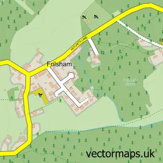
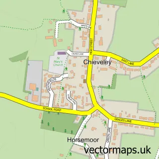
This Hampstead Norreys street map is a detailed vector street map covering a 750m x 750m area. Select a larger area to create and download your own vector street map of Hampstead Norreys.
The 750-metre map sample for Hampstead Norreys covers 165 mapped buildings and approximately 8.8 km of road detail, of which 9 named roads are named. The immediate area includes 1 school, 1 pub and 1 MOT station within 2 miles. The wider area around Hampstead Norreys features 2 food and drink venues and 1 hotel. To create a larger or custom map of Hampstead Norreys, the map builder lets you define your own coverage area and download editable SVG, PDF and PNG files.
Create a larger editable map of Hampstead Norreys
Choose any area you need and generate a high-quality vector map instantly. Perfect for print, planning, design, business and personal use.

This Hampstead Norreys street map in Berkshire is available as downloadable SVG, PDF and PNG map files, or as a printed map for planning, business, display, education, local information and design work. You can also create a larger custom map area using the map selector.
What this Hampstead Norreys map sample shows
Hampstead Norreys lies within Hampstead Norreys Cp parish, part of Ridgeway ward in the West Berkshire local authority area. The postcode geography for this area includes the RG postcode area, the RG18 postcode district and the RG18 0 postcode sector. Residents fall under the Nhs Buckinghamshire, Oxfordshire And Berkshire West Integrated Care Board for NHS services.
Local features near Hampstead Norreys
Within 2 milesAmenities and services in and around Hampstead Norreys.
Administrative and postcode information for Hampstead Norreys
The local authority covering Hampstead Norreys is West Berkshire, within the county of Berkshire. The settlement lies within Ridgeway ward and Hampstead Norreys Cp civil parish. The RG18 postcode district and RG18 0 postcode sector serve the immediate area. NHS provision in the area is delivered through Royal Berkshire Nhs Foundation Trust.
Nearby street map samples around Hampstead Norreys

More street maps in Berkshire
750 metre map area coverage
Boundary, postcode and point of interest information for the 750m x 750m rectangle centred on this sample map.
Boundaries containing map centre
Constituency: Reading West and Mid Berkshire Co Const
District: West Berkshire
Icb: NHS Thames Valley ICB
Parish: Hampstead Norreys CP
Police Force: thames valley
Postcode District: RG18
Postcode Sector: RG18 0
Ward: Ridgeway Ward
Nearby boundaries intersecting sample
No additional intersecting boundaries found.
Postcode coverage
POI category counts
Gym: 2
Anglican Church: 1
Beauty Salon: 1
Bed And Breakfast: 1
Beer Wine And Spirits: 1
Cafe: 1
Church Cathedral: 1
Community Center: 1
Dog Walkers: 1
Elementary School: 1
Sample points of interest
- Hampstead Norreys: St Mary the Virgin
- Kure Skin and Wellness
- Manor Farm House Bed and Breakfast
- West Berkshire Brewery Co. Ltd.
- Hampstead Norreys Community Shop & Cafe
- St Mary’s Church, Hampstead Norreys
- Hampstead Norreys Village Hall
- Dog-Trainer
- Hampstead Norreys Church of England Primary School
- Arland Craik Personal Trainer
- Hampstead Norreys Cricket Club
- Mark Kemp Hair Gallery
Create a larger editable map of Hampstead Norreys
This sample shows only a 750 metre area. To create a larger map of Hampstead Norreys, use our map builder to choose your own coverage area, add titles and download editable SVG, PDF and PNG files.
Create a custom map of Hampstead Norreys