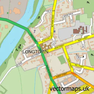
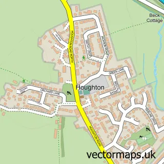
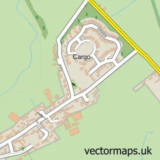
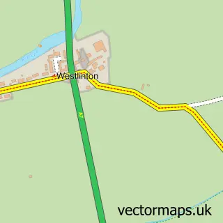
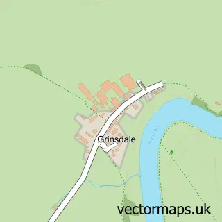
This Harker street map is a detailed vector street map covering a 750m x 750m area. Select a larger area to create and download your own vector street map of Harker.
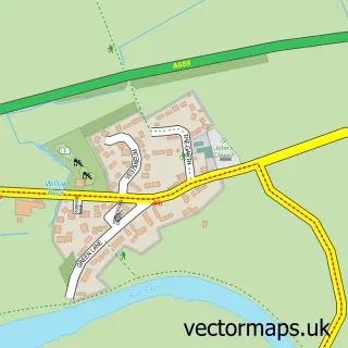
The 750-metre map sample for Harker covers 91 mapped buildings and approximately 4.6 km of road detail, of which 1 named road are named. The immediate area includes 1 MOT station, with 16 within 2 miles. The wider area around Harker features 1 food and drink venue and 2 campsites within 2 miles. To create a larger or custom map of Harker, the map builder lets you define your own coverage area and download editable SVG, PDF and PNG files.
Create a larger editable map of Harker
Choose any area you need and generate a high-quality vector map instantly. Perfect for print, planning, design, business and personal use.

This Harker street map in Cumbria is available as downloadable SVG, PDF and PNG map files, or as a printed map for planning, business, display, education, local information and design work. You can also create a larger custom map area using the map selector.
What this Harker map sample shows
Harker lies within Rockcliffe Cp parish, part of Longtown & The Border ward in the Cumberland local authority area. The postcode geography for this area includes the CA postcode area, the CA6 postcode district and the CA6 4 postcode sector. Residents fall under the Nhs North East And North Cumbria Integrated Care Board for NHS services.
Local features near Harker
Within 2 milesAmenities and services in and around Harker.
Administrative and postcode information for Harker
The local authority covering Harker is Cumberland, within the county of Cumbria. The settlement lies within Longtown & The Border ward and Rockcliffe Cp civil parish. The CA6 postcode district and CA6 4 postcode sector serve the immediate area. NHS provision in the area is delivered through North Cumbria Integrated Care Nhs Foundation Trust.
Nearby street map samples around Harker

More street maps in Cumbria
750 metre map area coverage
Boundary, postcode and point of interest information for the 750m x 750m rectangle centred on this sample map.
Boundaries containing map centre
Constituency: Carlisle Co Const
District: Cumberland
Icb: NHS North East and North Cumbria ICB
Parish: Rockcliffe CP
Police Force: cumbria
Postcode District: CA6
Postcode Sector: CA6 4
Ward: Longtown Ward
Nearby boundaries intersecting sample
Parish: Kingmoor CP, Stanwix Rural CP
Ward: Dalston and Burgh Ward, Houghton and Irthington Ward
Postcode coverage
POI category counts
Beauty Salon: 1
Building Supply Store: 1
Business To Business: 1
Car Dealer: 1
Car Wash: 1
Coffee Shop: 1
Education: 1
Fence And Gate Sales Service: 1
Flowers And Gifts Shop: 1
Gas Station: 1
Sample points of interest
- Becker Beauty Carlisle
- Harker Garden Buildings Limited
- Laing Timber
- Robert Little Garages
- M&S Valeting
- Laing's
- Holistic Academy
- H Fencing and Garden Services
- Mils & Boo Scented Soy Candles - Carlisle
- Harker Service Station
- Laing Timber Products Limited
- Ideal Living Interiors
Create a larger editable map of Harker
This sample shows only a 750 metre area. To create a larger map of Harker, use our map builder to choose your own coverage area, add titles and download editable SVG, PDF and PNG files.
Create a custom map of Harker