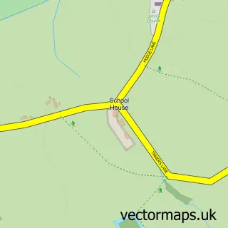
This Kingstone street map is a detailed vector street map covering a 750m x 750m area. Select a larger area to create and download your own vector street map of Kingstone.
The 750-metre map sample for Kingstone covers 166 mapped buildings and approximately 9.4 km of road detail, of which 8 named roads are named. The immediate area includes 1 school and 2 pubs. The wider area around Kingstone features 2 food and drink venues. To create a larger or custom map of Kingstone, the map builder lets you define your own coverage area and download editable SVG, PDF and PNG files.
Create a larger editable map of Kingstone
Choose any area you need and generate a high-quality vector map instantly. Perfect for print, planning, design, business and personal use.

This Kingstone street map in Staffordshire is available as downloadable SVG, PDF and PNG map files, or as a printed map for planning, business, display, education, local information and design work. You can also create a larger custom map area using the map selector.
What this Kingstone map sample shows
Kingstone lies within Kingstone Cp parish, part of Bagots ward in the East Staffordshire District (B) local authority area. The postcode geography for this area includes the ST postcode area, the ST14 postcode district and the ST14 8 postcode sector. Residents fall under the Nhs Staffordshire And Stoke-On-Trent Integrated Care Board for NHS services.
Local features near Kingstone
Within 2 milesAmenities and services in and around Kingstone.
Administrative and postcode information for Kingstone
Kingstone lies within Kingstone Cp parish, part of Bagots ward in the East Staffordshire District (B) local authority area. The postcode geography for this area includes the ST postcode area, the ST14 postcode district and the ST14 8 postcode sector. Residents fall under the Nhs Staffordshire And Stoke-On-Trent Integrated Care Board for NHS services.
Nearby street map samples around Kingstone


More street maps in Staffordshire
750 metre map area coverage
Boundary, postcode and point of interest information for the 750m x 750m rectangle centred on this sample map.
Boundaries containing map centre
Constituency: Lichfield Co Const
County: Staffordshire County
District: East Staffordshire District (B)
Icb: NHS Staffordshire and Stoke-on-Trent ICB
Parish: Kingstone CP
Police Force: staffordshire
Postcode District: ST14
Postcode Sector: ST14 8
Ward: Blythe Ward
Nearby boundaries intersecting sample
No additional intersecting boundaries found.
Postcode coverage
POI category counts
Bar: 2
Pub: 2
Anglican Church: 1
Building Supply Store: 1
Driving School: 1
Eat And Drink: 1
Elementary School: 1
Home Cleaning: 1
Home Improvement Store: 1
Printing Services: 1
Sample points of interest
- Kingstone St. John the Baptist
- Privilege Cafe Bar Lounge
- Shrewsbury Arms
- JCB Heavy Products
- Aok
- The SHED Shop
- Talbot First School
- Blast Cleaning Renovation Services
- MPL Home Improvements
- Kingstone Community Society
- The Shrewsbury Arms
- The Shrewsbury Arms
Create a larger editable map of Kingstone
This sample shows only a 750 metre area. To create a larger map of Kingstone, use our map builder to choose your own coverage area, add titles and download editable SVG, PDF and PNG files.
Create a custom map of Kingstone