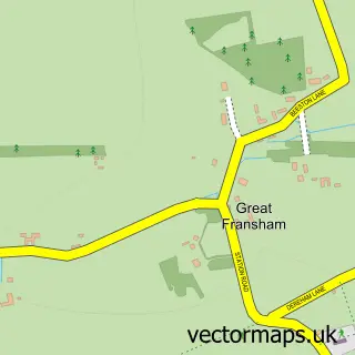
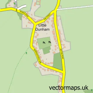
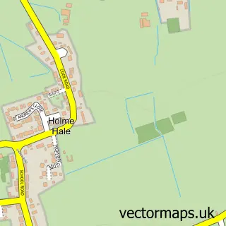
This Little Fransham street map is a detailed vector street map covering a 750m x 750m area. Select a larger area to create and download your own vector street map of Little Fransham.
The 750-metre map sample for Little Fransham covers 107 mapped buildings and approximately 6.7 km of road detail, of which 3 named roads are named. The immediate area includes 2 pubs. The wider area around Little Fransham features 2 food and drink venues. To create a larger or custom map of Little Fransham, the map builder lets you define your own coverage area and download editable SVG, PDF and PNG files.
Create a larger editable map of Little Fransham
Choose any area you need and generate a high-quality vector map instantly. Perfect for print, planning, design, business and personal use.

This Little Fransham street map in Norfolk is available as downloadable SVG, PDF and PNG map files, or as a printed map for planning, business, display, education, local information and design work. You can also create a larger custom map area using the map selector.
What this Little Fransham map sample shows
Little Fransham lies within Fransham Cp parish, part of Launditch ward in the Breckland District local authority area. The postcode geography for this area includes the NR postcode area, the NR19 postcode district and the NR19 2 postcode sector. Residents fall under the Nhs Norfolk And Waveney Integrated Care Board for NHS services.
Local features near Little Fransham
Within 2 milesAmenities and services in and around Little Fransham.
Administrative and postcode information for Little Fransham
Little Fransham lies within Fransham Cp parish, part of Launditch ward in the Breckland District local authority area. The postcode geography for this area includes the NR postcode area, the NR19 postcode district and the NR19 2 postcode sector. Residents fall under the Nhs Norfolk And Waveney Integrated Care Board for NHS services.
Nearby street map samples around Little Fransham

More street maps in Norfolk
750 metre map area coverage
Boundary, postcode and point of interest information for the 750m x 750m rectangle centred on this sample map.
Boundaries containing map centre
Constituency: Mid Norfolk Co Const
County: Norfolk County
District: Breckland District
Icb: NHS Norfolk and Waveney ICB
Parish: Fransham CP
Police Force: norfolk
Postcode District: NR19
Postcode Sector: NR19 2
Ward: Launditch Ward
Nearby boundaries intersecting sample
No additional intersecting boundaries found.
Postcode coverage
POI category counts
Pub: 2
Rental Kiosks: 2
Anglican Church: 1
Automotive Services And Repair: 1
Butcher Shop: 1
Sample points of interest
- Little Fransham: St Mary
- Dacsoft
- Willgress of Fransham - Butcher & Deli
- The Canary And Linnet
- The Canary and Linnet
- Karan Retail Ltd @ Newtoll Service Station
- Shell UK @ Kings Lynn Core 2
Create a larger editable map of Little Fransham
This sample shows only a 750 metre area. To create a larger map of Little Fransham, use our map builder to choose your own coverage area, add titles and download editable SVG, PDF and PNG files.
Create a custom map of Little Fransham