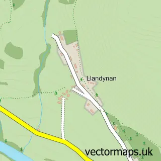
This Llandegla street map is a detailed vector street map covering a 750m x 750m area. Select a larger area to create and download your own vector street map of Llandegla.
The 750-metre map sample for Llandegla covers 74 mapped buildings and approximately 5.9 km of road detail, of which 3 named roads are named. The immediate area includes 1 school. The wider area around Llandegla features 1 campsite within 2 miles. To create a larger or custom map of Llandegla, the map builder lets you define your own coverage area and download editable SVG, PDF and PNG files.
Create a larger editable map of Llandegla
Choose any area you need and generate a high-quality vector map instantly. Perfect for print, planning, design, business and personal use.

This Llandegla street map in Clwyd is available as downloadable SVG, PDF and PNG map files, or as a printed map for planning, business, display, education, local information and design work. You can also create a larger custom map area using the map selector.
What this Llandegla map sample shows
Llandegla lies within Llandegla Community parish, part of Llanarmon-Yn-Ial/Llandegla ward in the Sir Ddinbych - Denbighshire local authority area. The postcode geography for this area includes the LL postcode area, the LL11 postcode district and the LL11 3 postcode sector. Residents fall under the Betsi Cadwaladr University Health Board for NHS services.
Local features near Llandegla
Within 2 milesAmenities and services in and around Llandegla.
Administrative and postcode information for Llandegla
The local authority covering Llandegla is Sir Ddinbych - Denbighshire, within the county of Clwyd. The settlement lies within Llanarmon-Yn-Ial/Llandegla ward and Llandegla Community civil parish. The LL11 postcode district and LL11 3 postcode sector serve the immediate area. NHS provision in the area is delivered through Betsi Cadwaladr University Health Board.
Nearby street map samples around Llandegla

More street maps in Clwyd
750 metre map area coverage
Boundary, postcode and point of interest information for the 750m x 750m rectangle centred on this sample map.
Boundaries containing map centre
Constituency: Clwyd East Co Const
District: Sir Ddinbych - Denbighshire
Icb: Betsi Cadwaladr University
Parish: Llandegla Community
Police Force: north wales
Postcode District: LL11
Postcode Sector: LL11 3
Nearby boundaries intersecting sample
No additional intersecting boundaries found.
Postcode coverage
POI category counts
Korean Grocery Store: 2
Bed And Breakfast: 1
Broadcasting Media Production: 1
Church Cathedral: 1
Convenience Store: 1
Cottage: 1
Educational Services: 1
Elementary School: 1
Musical Instrument Store: 1
Post Office: 1
Sample points of interest
- Bryn Dwr Pods and B&B
- Eastwood Media
- St Tecla's Church
- Llandegla Community Shop
- Bellringers Cottage
- L2D-David Lawton Driving School
- Ysgol Dyffryn Ial
- Llandegla Mobile Post Office
- Post Office-Llandegla
- John Rogers Music
- Llandegla Post Office
Create a larger editable map of Llandegla
This sample shows only a 750 metre area. To create a larger map of Llandegla, use our map builder to choose your own coverage area, add titles and download editable SVG, PDF and PNG files.
Create a custom map of Llandegla