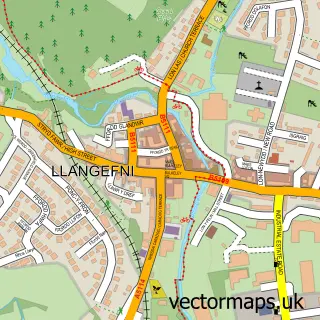
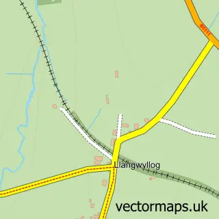
This Llannerch-y-Medd street map is a detailed vector street map covering a 750m x 750m area. Select a larger area to create and download your own vector street map of Llannerch-y-Medd.
The 750-metre map sample for Llannerch-y-Medd covers 163 mapped buildings and approximately 13.9 km of road detail, of which 13 named roads are named. The immediate area includes 1 school, 1 GP surgery, 3 pubs and 1 MOT station within 2 miles. The wider area around Llannerch-y-Medd features 4 food and drink venues. To create a larger or custom map of Llannerch-y-Medd, the map builder lets you define your own coverage area and download editable SVG, PDF and PNG files.
Create a larger editable map of Llannerch-y-Medd
Choose any area you need and generate a high-quality vector map instantly. Perfect for print, planning, design, business and personal use.

This Llannerch-y-Medd street map in Gwynedd is available as downloadable SVG, PDF and PNG map files, or as a printed map for planning, business, display, education, local information and design work. You can also create a larger custom map area using the map selector.
What this Llannerch-y-Medd map sample shows
Llannerch-y-Medd lies within Llannerch-Y-Medd Community parish, part of Talybolion ward in the Sir Ynys Mon - Isle Of Anglesey local authority area. The postcode geography for this area includes the LL postcode area, the LL71 postcode district and the LL71 8 postcode sector. Residents fall under the Betsi Cadwaladr University Health Board for NHS services.
Local features near Llannerch-y-Medd
Within 2 milesAmenities and services in and around Llannerch-y-Medd.
Administrative and postcode information for Llannerch-y-Medd
Llannerch-y-Medd lies within Llannerch-Y-Medd Community parish, part of Talybolion ward in the Sir Ynys Mon - Isle Of Anglesey local authority area. The postcode geography for this area includes the LL postcode area, the LL71 postcode district and the LL71 8 postcode sector. Residents fall under the Betsi Cadwaladr University Health Board for NHS services.
Nearby street map samples around Llannerch-y-Medd


More street maps in Gwynedd
750 metre map area coverage
Boundary, postcode and point of interest information for the 750m x 750m rectangle centred on this sample map.
Boundaries containing map centre
Constituency: Ynys Mon Co Const
District: Sir Ynys Mon - Isle of Anglesey
Icb: Betsi Cadwaladr University
Parish: Llannerch-y-Medd Community
Police Force: north wales
Postcode District: LL71
Postcode Sector: LL71 8
Nearby boundaries intersecting sample
Postcode Sector: LL71 7
Postcode coverage
POI category counts
Pub: 3
Convenience Store: 2
Hair Salon: 2
Shipping Center: 2
Aquatic Pet Store: 1
Atms: 1
Church Cathedral: 1
Community Services Non Profits: 1
Construction Services: 1
Professional Services: 1
Sample points of interest
- Mon Aquatics
- Morrisons Daily - Llanerchymedd Bridge Stre, 5 Bridge Street
- St Mary's Church
- Annie's Orphans Charity Shop
- G. O. Hughes Building and Groundworks
- McColl's
- Morrisons Daily
- Hair By Mand
- Salon Y Medd
- T Roberts Glazing
- The Bull Inn
- Twr llan
Create a larger editable map of Llannerch-y-Medd
This sample shows only a 750 metre area. To create a larger map of Llannerch-y-Medd, use our map builder to choose your own coverage area, add titles and download editable SVG, PDF and PNG files.
Create a custom map of Llannerch-y-Medd