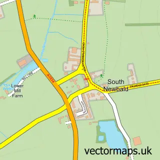
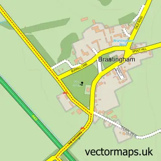
This North Newbald street map is a detailed vector street map covering a 750m x 750m area. Select a larger area to create and download your own vector street map of North Newbald.
The 750-metre map sample for North Newbald covers 302 mapped buildings and approximately 11.5 km of road detail, of which 24 named roads are named. The immediate area includes 1 school and 2 pubs. The wider area around North Newbald features 2 food and drink venues and 2 hotels. To create a larger or custom map of North Newbald, the map builder lets you define your own coverage area and download editable SVG, PDF and PNG files.
Create a larger editable map of North Newbald
Choose any area you need and generate a high-quality vector map instantly. Perfect for print, planning, design, business and personal use.

This North Newbald street map in East Riding of Yorkshire is available as downloadable SVG, PDF and PNG map files, or as a printed map for planning, business, display, education, local information and design work. You can also create a larger custom map area using the map selector.
What this North Newbald map sample shows
North Newbald lies within Newbald Cp parish, part of Beverley Rural ward in the East Riding Of Yorkshire local authority area. The postcode geography for this area includes the YO postcode area, the YO43 postcode district and the YO43 4 postcode sector. Residents fall under the Nhs Humber And North Yorkshire Integrated Care Board for NHS services.
Local features near North Newbald
Within 2 milesAmenities and services in and around North Newbald.
Administrative and postcode information for North Newbald
North Newbald lies within Newbald Cp parish, part of Beverley Rural ward in the East Riding Of Yorkshire local authority area. The postcode geography for this area includes the YO postcode area, the YO43 postcode district and the YO43 4 postcode sector. Residents fall under the Nhs Humber And North Yorkshire Integrated Care Board for NHS services.
Nearby street map samples around North Newbald

More street maps in East Riding of Yorkshire
750 metre map area coverage
Boundary, postcode and point of interest information for the 750m x 750m rectangle centred on this sample map.
Boundaries containing map centre
Constituency: Beverley and Holderness Co Const
District: East Riding of Yorkshire
Icb: NHS Humber and North Yorkshire ICB
Parish: Newbald CP
Police Force: humberside
Postcode District: YO43
Postcode Sector: YO43 4
Ward: Beverley Rural Ward
Nearby boundaries intersecting sample
No additional intersecting boundaries found.
Postcode coverage
POI category counts
Hotel: 2
Pub: 2
Advertising Agency: 1
Anglican Church: 1
Antique Store: 1
Beauty And Spa: 1
Beauty Salon: 1
Charity Organization: 1
Community Center: 1
Community Services Non Profits: 1
Sample points of interest
- Penement Design
- St Nicholas
- Beresford Antiques
- Birch House Beauty
- HD Skin
- WIN Newbald WI
- Newbald Village Hall
- Newbald Youth Project
- APA Building and Joinery Contractors
- Newbald Primary School
- Tomlinson Opticians
- Wolds Way Blooms
Create a larger editable map of North Newbald
This sample shows only a 750 metre area. To create a larger map of North Newbald, use our map builder to choose your own coverage area, add titles and download editable SVG, PDF and PNG files.
Create a custom map of North Newbald