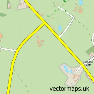
This Penley street map is a detailed vector street map covering a 750m x 750m area. Select a larger area to create and download your own vector street map of Penley.
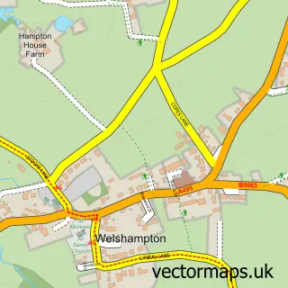
The 750-metre map sample for Penley covers 155 mapped buildings and approximately 13.4 km of road detail, of which 13 named roads are named. The immediate area includes 2 schools and 1 MOT station within 2 miles. The wider area around Penley features 1 food and drink venue and 2 campsites within 2 miles. To create a larger or custom map of Penley, the map builder lets you define your own coverage area and download editable SVG, PDF and PNG files.
Create a larger editable map of Penley
Choose any area you need and generate a high-quality vector map instantly. Perfect for print, planning, design, business and personal use.

This Penley street map in Clwyd is available as downloadable SVG, PDF and PNG map files, or as a printed map for planning, business, display, education, local information and design work. You can also create a larger custom map area using the map selector.
What this Penley map sample shows
Penley lies within Maelor South Community parish, part of Overton ward in the Wrecsam - Wrexham local authority area. The postcode geography for this area includes the LL postcode area, the LL13 postcode district and the LL13 0 postcode sector. Residents fall under the Betsi Cadwaladr University Health Board for NHS services.
Local features near Penley
Within 2 milesAmenities and services in and around Penley.
Administrative and postcode information for Penley
Penley lies within Maelor South Community parish, part of Overton ward in the Wrecsam - Wrexham local authority area. The postcode geography for this area includes the LL postcode area, the LL13 postcode district and the LL13 0 postcode sector. Residents fall under the Betsi Cadwaladr University Health Board for NHS services.
Nearby street map samples around Penley

More street maps in Clwyd
750 metre map area coverage
Boundary, postcode and point of interest information for the 750m x 750m rectangle centred on this sample map.
Boundaries containing map centre
Constituency: Wrexham Co Const
District: Wrecsam - Wrexham
Icb: Betsi Cadwaladr University
Parish: Maelor South Community
Police Force: north wales
Postcode District: LL13
Postcode Sector: LL13 0
Nearby boundaries intersecting sample
No additional intersecting boundaries found.
Postcode coverage
POI category counts
Retail: 4
Contractor: 2
Hospital: 2
Professional Services: 2
Active Life: 1
Brewery: 1
Business Manufacturing And Supply: 1
Cafe: 1
Carpenter: 1
Charity Organization: 1
Sample points of interest
- RangeBay
- Penley Brewing Co.
- Range Solutions
- The Red Hen Community Cafe
- Immony Kitchens & Furniture
- Penley Rainbow Centre
- St Mary Magdalene Church
- The Rainbow Foundation
- David Smith Joinery Ltd
- Dee valley spray solutions Ltd
- Penley stores
- Madras Aided School
Create a larger editable map of Penley
This sample shows only a 750 metre area. To create a larger map of Penley, use our map builder to choose your own coverage area, add titles and download editable SVG, PDF and PNG files.
Create a custom map of Penley