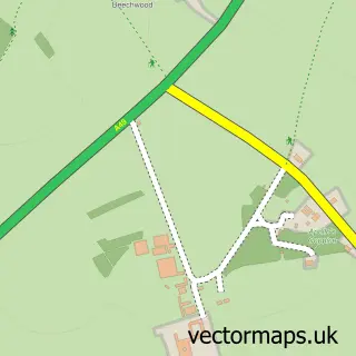
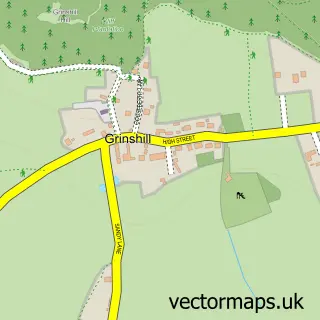
This Shawbury street map is a detailed vector street map covering a 750m x 750m area. Select a larger area to create and download your own vector street map of Shawbury.
The 750-metre map sample for Shawbury covers 332 mapped buildings and approximately 13.4 km of road detail, of which 16 named roads are named. The immediate area includes 1 GP surgery within 2 miles, 2 pubs and 1 MOT station, with 2 within 2 miles. The wider area around Shawbury features 2 food and drink venues. To create a larger or custom map of Shawbury, the map builder lets you define your own coverage area and download editable SVG, PDF and PNG files.
Create a larger editable map of Shawbury
Choose any area you need and generate a high-quality vector map instantly. Perfect for print, planning, design, business and personal use.

This Shawbury street map in Shropshire is available as downloadable SVG, PDF and PNG map files, or as a printed map for planning, business, display, education, local information and design work. You can also create a larger custom map area using the map selector.
What this Shawbury map sample shows
Shawbury lies within Shawbury Cp parish, part of Shawbury ward in the Shropshire local authority area. The postcode geography for this area includes the SY postcode area, the SY4 postcode district and the SY4 4 postcode sector. Residents fall under the Nhs Shropshire, Telford And Wrekin Integrated Care Board for NHS services.
Local features near Shawbury
Within 2 milesAmenities and services in and around Shawbury.
Administrative and postcode information for Shawbury
Shawbury lies within Shawbury Cp parish, part of Shawbury ward in the Shropshire local authority area. The postcode geography for this area includes the SY postcode area, the SY4 postcode district and the SY4 4 postcode sector. Residents fall under the Nhs Shropshire, Telford And Wrekin Integrated Care Board for NHS services.
Nearby street map samples around Shawbury

More street maps in Shropshire
750 metre map area coverage
Boundary, postcode and point of interest information for the 750m x 750m rectangle centred on this sample map.
Boundaries containing map centre
Constituency: North Shropshire Co Const
District: Shropshire
Icb: NHS Shropshire Telford and Wrekin ICB
Parish: Shawbury CP
Police Force: west mercia
Postcode District: SY4
Postcode Sector: SY4 4
Nearby boundaries intersecting sample
No additional intersecting boundaries found.
Postcode coverage
POI category counts
Fabric Store: 3
Pub: 2
Taxi Service: 2
Anglican Church: 1
Architectural Designer: 1
Art Gallery: 1
Auto Electrical Repair: 1
Bakery: 1
Beauty And Spa: 1
Beauty Salon: 1
Sample points of interest
- Shawbury S.Mary the Virgin
- House Gecko Architectural Services
- Global Aviation Art Gallery
- Shropshire Electrical Solutions
- The Bakery
- Sophisticutz Hair & Beauty
- Locks A Lash
- Woods of Shawbury Butchers
- Shawbury Village Hall
- Page Communication
- Dave Allmark Surfacing Contractor
- Shawbury Service Station
Create a larger editable map of Shawbury
This sample shows only a 750 metre area. To create a larger map of Shawbury, use our map builder to choose your own coverage area, add titles and download editable SVG, PDF and PNG files.
Create a custom map of Shawbury