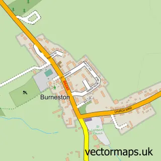
This Snape street map is a detailed vector street map covering a 750m x 750m area. Select a larger area to create and download your own vector street map of Snape.
The 750-metre map sample for Snape covers 140 mapped buildings and approximately 6.2 km of road detail, of which 5 named roads are named. The immediate area includes 1 school and 1 pub. The wider area around Snape features 2 food and drink venues. To create a larger or custom map of Snape, the map builder lets you define your own coverage area and download editable SVG, PDF and PNG files.
Create a larger editable map of Snape
Choose any area you need and generate a high-quality vector map instantly. Perfect for print, planning, design, business and personal use.

This Snape street map in North Yorkshire is available as downloadable SVG, PDF and PNG map files, or as a printed map for planning, business, display, education, local information and design work. You can also create a larger custom map area using the map selector.
What this Snape map sample shows
Snape lies within Snape With Thorp Cp parish, part of Tanfield ward in the North Yorkshire local authority area. The postcode geography for this area includes the DL postcode area, the DL8 postcode district and the DL8 2 postcode sector. Residents fall under the Nhs Humber And North Yorkshire Integrated Care Board for NHS services.
Local features near Snape
Within 2 milesAmenities and services in and around Snape.
Administrative and postcode information for Snape
Snape lies within Snape With Thorp Cp parish, part of Tanfield ward in the North Yorkshire local authority area. The postcode geography for this area includes the DL postcode area, the DL8 postcode district and the DL8 2 postcode sector. Residents fall under the Nhs Humber And North Yorkshire Integrated Care Board for NHS services.
Nearby street map samples around Snape


More street maps in North Yorkshire
750 metre map area coverage
Boundary, postcode and point of interest information for the 750m x 750m rectangle centred on this sample map.
Boundaries containing map centre
Constituency: Thirsk and Malton Co Const
District: North Yorkshire
Icb: NHS Humber and North Yorkshire ICB
Parish: Snape with Thorp CP
Police Force: north yorkshire
Postcode District: DL8
Postcode Sector: DL8 2
Nearby boundaries intersecting sample
No additional intersecting boundaries found.
Postcode coverage
POI category counts
Business Management Services: 1
Contractor: 1
Elementary School: 1
Event Planning: 1
Fishmonger: 1
Pub: 1
Restaurant: 1
Sample points of interest
- Training Reality Ltd.
- Prices Paving & Tile
- Snape Community Primary School
- KNW Training - Kielder Newport West
- Carricks Fish Ltd
- The Castle Arms Inn
- Castle Arms Inn Pub
Create a larger editable map of Snape
This sample shows only a 750 metre area. To create a larger map of Snape, use our map builder to choose your own coverage area, add titles and download editable SVG, PDF and PNG files.
Create a custom map of Snape