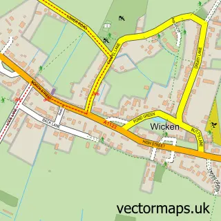
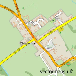
This Soham street map is a detailed vector street map covering a 750m x 750m area. Select a larger area to create and download your own vector street map of Soham.
The 750-metre map sample for Soham covers 553 mapped buildings and approximately 14.5 km of road detail, of which 31 named roads are named. The immediate area includes 1 school, 1 GP surgery, 3 pubs and 1 MOT station, with 5 within 2 miles. The wider area around Soham features 12 food and drink venues. To create a larger or custom map of Soham, the map builder lets you define your own coverage area and download editable SVG, PDF and PNG files.
Create a larger editable map of Soham
Choose any area you need and generate a high-quality vector map instantly. Perfect for print, planning, design, business and personal use.

This Soham street map in Cambridgeshire is available as downloadable SVG, PDF and PNG map files, or as a printed map for planning, business, display, education, local information and design work. You can also create a larger custom map area using the map selector.
What this Soham map sample shows
Soham lies within Soham Cp parish, part of Soham North ward in the East Cambridgeshire District local authority area. The postcode geography for this area includes the CB postcode area, the CB7 postcode district and the CB7 5 postcode sector. Residents fall under the Nhs Cambridgeshire And Peterborough Integrated Care Board for NHS services.
Local features near Soham
Within 2 milesAmenities and services in and around Soham.
Administrative and postcode information for Soham
Soham lies within Soham Cp parish, part of Soham North ward in the East Cambridgeshire District local authority area. The postcode geography for this area includes the CB postcode area, the CB7 postcode district and the CB7 5 postcode sector. Residents fall under the Nhs Cambridgeshire And Peterborough Integrated Care Board for NHS services.
Nearby street map samples around Soham

More street maps in Cambridgeshire
750 metre map area coverage
Boundary, postcode and point of interest information for the 750m x 750m rectangle centred on this sample map.
Boundaries containing map centre
Constituency: Ely and East Cambridgeshire Co Const
County: Cambridgeshire County
District: East Cambridgeshire District
Icb: NHS Central East ICB
Parish: Soham CP
Police Force: cambridgeshire
Postcode District: CB7
Postcode Sector: CB7 5
Ward: Soham South Ward
Nearby boundaries intersecting sample
Ward: Soham North Ward
Postcode coverage
POI category counts
Hair Salon: 7
Restaurant: 5
Beauty Salon: 4
Gym: 4
Bar: 3
Barber: 3
Cafe: 3
Flowers And Gifts Shop: 3
Grocery Store: 3
Pet Groomer: 3
Sample points of interest
- Soham Recreation Ground
- KNA Creative
- Jessica Penberth
- Andrew Fleet Limited
- KD Academy
- Asda Soham
- The Cooperative Food (BF) Soham, Soham
- Cams Detailing
- Lloyds Bank
- Soham Baptist Church
- Greene King
- Red Lion
Create a larger editable map of Soham
This sample shows only a 750 metre area. To create a larger map of Soham, use our map builder to choose your own coverage area, add titles and download editable SVG, PDF and PNG files.
Create a custom map of Soham