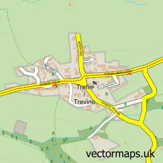
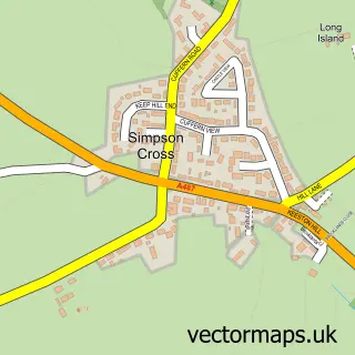
This St Davids street map is a detailed vector street map covering a 750m x 750m area. Select a larger area to create and download your own vector street map of St Davids.
The 750-metre map sample for St Davids covers 397 mapped buildings and approximately 20.5 km of road detail, of which 28 named roads are named. The immediate area includes 1 GP surgery within 2 miles, 2 pubs and 1 MOT station within 2 miles. The wider area around St Davids features 16 tourism points of interest, 18 food and drink venues and 14 hotels. To create a larger or custom map of St Davids, the map builder lets you define your own coverage area and download editable SVG, PDF and PNG files.
Create a larger editable map of St Davids
Choose any area you need and generate a high-quality vector map instantly. Perfect for print, planning, design, business and personal use.

This St Davids street map in Dyfed is available as downloadable SVG, PDF and PNG map files, or as a printed map for planning, business, display, education, local information and design work. You can also create a larger custom map area using the map selector.
What this St Davids map sample shows
St Davids lies within St. David's Community parish, part of St. David's ward in the Sir Benfro - Pembrokeshire local authority area. The postcode geography for this area includes the SA postcode area, the SA62 postcode district and the SA62 6 postcode sector. Residents fall under the Hywel Dda University Health Board for NHS services.
Local features near St Davids
Within 2 milesAmenities and services in and around St Davids.
Administrative and postcode information for St Davids
St Davids lies within St. David's Community parish, part of St. David's ward in the Sir Benfro - Pembrokeshire local authority area. The postcode geography for this area includes the SA postcode area, the SA62 postcode district and the SA62 6 postcode sector. Residents fall under the Hywel Dda University Health Board for NHS services.
Nearby street map samples around St Davids
More street maps in Dyfed
750 metre map area coverage
Boundary, postcode and point of interest information for the 750m x 750m rectangle centred on this sample map.
Boundaries containing map centre
Constituency: Mid and South Pembrokeshire Co Const
District: Sir Benfro - Pembrokeshire
Icb: Hywel Dda
Parish: St. David's Community
Police Force: dyfed-powys
Postcode District: SA62
Postcode Sector: SA62 6
Nearby boundaries intersecting sample
No additional intersecting boundaries found.
Postcode coverage
POI category counts
Hotel: 14
Art Gallery: 9
Restaurant: 9
Cafe: 7
Landmark And Historical Building: 7
Bed And Breakfast: 6
Flowers And Gifts Shop: 6
Holiday Rental Home: 5
Attractions And Activities: 4
Boat Tours: 4
Sample points of interest
- Llys y Faenor
- Longhouse
- Alchemy Acupuncture
- The Responsible Agency
- St Davids Cathedral
- Shalom House Charity Shop - St Davids
- Chris Snushall Design
- David Haward Associates
- Albion Gallery
- Goat Street Gallery
- Jacki Sime Photography & Gallery
- New Street Gallery
Create a larger editable map of St Davids
This sample shows only a 750 metre area. To create a larger map of St Davids, use our map builder to choose your own coverage area, add titles and download editable SVG, PDF and PNG files.
Create a custom map of St Davids