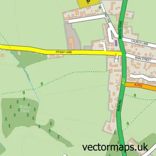
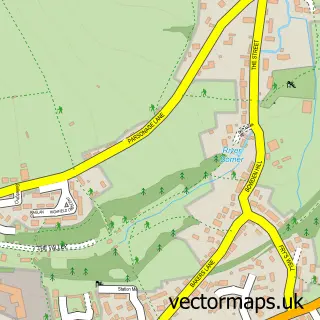
This Ston Easton street map is a detailed vector street map covering a 750m x 750m area. Select a larger area to create and download your own vector street map of Ston Easton.
The 750-metre map sample for Ston Easton covers 92 mapped buildings and approximately 9.5 km of road detail, of which 3 named roads are named. The immediate area includes 1 MOT station within 2 miles. To create a larger or custom map of Ston Easton, the map builder lets you define your own coverage area and download editable SVG, PDF and PNG files.
Create a larger editable map of Ston Easton
Choose any area you need and generate a high-quality vector map instantly. Perfect for print, planning, design, business and personal use.

This Ston Easton street map in Somerset is available as downloadable SVG, PDF and PNG map files, or as a printed map for planning, business, display, education, local information and design work. You can also create a larger custom map area using the map selector.
What this Ston Easton map sample shows
Ston Easton lies within Ston Easton Cp parish, part of Chewton Mendip And Ston Easton ward in the Somerset local authority area. The postcode geography for this area includes the BA postcode area, the BA3 postcode district and the BA3 4 postcode sector. Residents fall under the Nhs Somerset Integrated Care Board for NHS services.
Local features near Ston Easton
Within 2 milesAmenities and services in and around Ston Easton.
Administrative and postcode information for Ston Easton
Ston Easton lies within Ston Easton Cp parish, part of Chewton Mendip And Ston Easton ward in the Somerset local authority area. The postcode geography for this area includes the BA postcode area, the BA3 postcode district and the BA3 4 postcode sector. Residents fall under the Nhs Somerset Integrated Care Board for NHS services.
Nearby street map samples around Ston Easton


More street maps in Somerset
750 metre map area coverage
Boundary, postcode and point of interest information for the 750m x 750m rectangle centred on this sample map.
Boundaries containing map centre
Constituency: Wells and Mendip Hills Co Const
District: Somerset
Icb: NHS Somerset ICB
Parish: Ston Easton CP
Police Force: avon and somerset
Postcode District: BA3
Postcode Sector: BA3 4
Nearby boundaries intersecting sample
No additional intersecting boundaries found.
Postcode coverage
POI category counts
Building Supply Store: 2
Anglican Church: 1
Antique Store: 1
Auto Loan Provider: 1
Church Cathedral: 1
Event Planning: 1
Excavation Service: 1
Financial Service: 1
Home And Garden: 1
Horse Riding: 1
Sample points of interest
- St Mary the Virgin, Ston Easton
- Materials 4 Building & Somerset Reclamation
- G Jones
- RM Penny Plant Hire & Demolition Ltd.
- RM Penny Plant Hire & Demolition Ltd.
- Church of the Blessed Virgin Mary
- Ston Easton Village Hall
- Pennys
- Mendip Business Finance
- The Somerset Shop
- Hay Street Riding Club
- Eastwater Systems
Create a larger editable map of Ston Easton
This sample shows only a 750 metre area. To create a larger map of Ston Easton, use our map builder to choose your own coverage area, add titles and download editable SVG, PDF and PNG files.
Create a custom map of Ston Easton