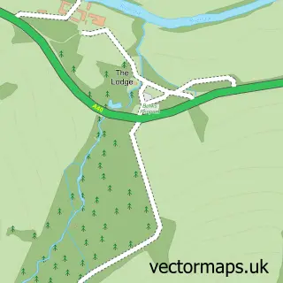
This Trecastle street map is a detailed vector street map covering a 750m x 750m area. Select a larger area to create and download your own vector street map of Trecastle.
The 750-metre map sample for Trecastle covers 104 mapped buildings and approximately 7.9 km of road detail, of which 2 named roads are named. The wider area around Trecastle features 4 tourism points of interest and 2 hotels. To create a larger or custom map of Trecastle, the map builder lets you define your own coverage area and download editable SVG, PDF and PNG files.
Create a larger editable map of Trecastle
Choose any area you need and generate a high-quality vector map instantly. Perfect for print, planning, design, business and personal use.

This Trecastle street map in Powys is available as downloadable SVG, PDF and PNG map files, or as a printed map for planning, business, display, education, local information and design work. You can also create a larger custom map area using the map selector.
What this Trecastle map sample shows
Trecastle lies within Llywel Community parish, part of Maescar/Llywel ward in the Powys - Powys local authority area. The postcode geography for this area includes the LD postcode area, the LD3 postcode district and the LD3 8 postcode sector. Residents fall under the Powys Teaching Health Board for NHS services.
Local features near Trecastle
Within 2 milesAmenities and services in and around Trecastle.
Administrative and postcode information for Trecastle
Trecastle lies within Llywel Community parish, part of Maescar/Llywel ward in the Powys - Powys local authority area. The postcode geography for this area includes the LD postcode area, the LD3 postcode district and the LD3 8 postcode sector. Residents fall under the Powys Teaching Health Board for NHS services.
Nearby street map samples around Trecastle


More street maps in Powys
750 metre map area coverage
Boundary, postcode and point of interest information for the 750m x 750m rectangle centred on this sample map.
Boundaries containing map centre
Constituency: Brecon, Radnor and Cwm Tawe Co Const
District: Powys - Powys
Icb: Powys Teaching
Parish: Llywel Community
Police Force: dyfed-powys
Postcode District: LD3
Postcode Sector: LD3 8
Nearby boundaries intersecting sample
No additional intersecting boundaries found.
Postcode coverage
POI category counts
Antique Store: 2
Hotel: 2
Landmark And Historical Building: 2
Building Supply Store: 1
Campground: 1
Castle: 1
Community Center: 1
Electrician: 1
Inn: 1
Naturopathic Holistic: 1
Sample points of interest
- Kingdom of Rust, vintage Salvage Yard
- Trecastle Antique Centre
- Beacon Plant Ltd
- Ynysfaen Camping
- Trecastle Motte
- Trecastle Community Centre
- Abacus 123 Electrical Services
- Coachingmans Cottage
- Three Horseshoes Inn, Trecastle
- Castle Coaching Inn
- Bishops Town
- Castle Tump
Create a larger editable map of Trecastle
This sample shows only a 750 metre area. To create a larger map of Trecastle, use our map builder to choose your own coverage area, add titles and download editable SVG, PDF and PNG files.
Create a custom map of Trecastle