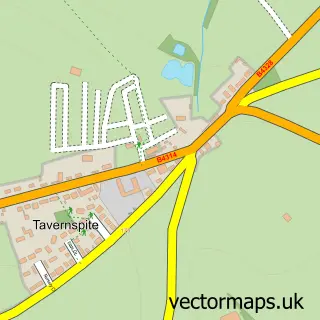
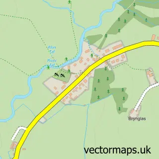
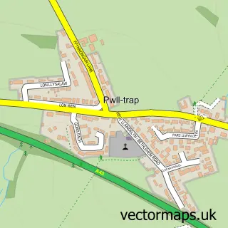
This Whitland street map is a detailed vector street map covering a 750m x 750m area. Select a larger area to create and download your own vector street map of Whitland.
The 750-metre map sample for Whitland covers 183 mapped buildings and approximately 7.6 km of road detail, of which 14 named roads are named. The immediate area includes 2 schools, 1 railway station, 3 pubs and 2 MOT stations. The wider area around Whitland features 4 tourism points of interest, 8 food and drink venues and 1 hotel. To create a larger or custom map of Whitland, the map builder lets you define your own coverage area and download editable SVG, PDF and PNG files.
Create a larger editable map of Whitland
Choose any area you need and generate a high-quality vector map instantly. Perfect for print, planning, design, business and personal use.

This Whitland street map in Dyfed is available as downloadable SVG, PDF and PNG map files, or as a printed map for planning, business, display, education, local information and design work. You can also create a larger custom map area using the map selector.
What this Whitland map sample shows
Whitland lies within Whitland Community parish, part of Whitland ward in the Sir Gaerfyrddin - Carmarthenshire local authority area. The postcode geography for this area includes the SA postcode area, the SA34 postcode district and the SA34 0 postcode sector. Residents fall under the Hywel Dda University Health Board for NHS services.
Local features near Whitland
Within 2 milesAmenities and services in and around Whitland.
Administrative and postcode information for Whitland
The local authority covering Whitland is Sir Gaerfyrddin - Carmarthenshire, within the county of Dyfed. The settlement lies within Whitland ward and Whitland Community civil parish. The SA34 postcode district and SA34 0 postcode sector serve the immediate area. NHS provision in the area is delivered through Hywel Dda University Health Board.
Nearby street map samples around Whitland

More street maps in Dyfed
750 metre map area coverage
Boundary, postcode and point of interest information for the 750m x 750m rectangle centred on this sample map.
Boundaries containing map centre
Constituency: Caerfyrddin Co Const
District: Sir Gaerfyrddin - Carmarthenshire
Icb: Hywel Dda
Parish: Whitland Community
Police Force: dyfed-powys
Postcode District: SA34
Postcode Sector: SA34 0
Nearby boundaries intersecting sample
No additional intersecting boundaries found.
Postcode coverage
POI category counts
Automotive Repair: 5
Dentist: 5
Convenience Store: 4
Sports Club And League: 4
Butcher Shop: 3
General Dentistry: 3
Pub: 3
Train Station: 3
Arts And Crafts: 2
Building Supply Store: 2
Sample points of interest
- Llewelyn Davies
- Robotic Milking Systems
- Gerald Blain Associates
- Gorsewen Arts
- Colourway
- Colourway Yarns
- The Cooperative Food (BF) Whitland
- David Harries & Co
- Associated Tyre Specialists
- Central Garage
- Phil Bowen Tyres
- Station Garage
Create a larger editable map of Whitland
This sample shows only a 750 metre area. To create a larger map of Whitland, use our map builder to choose your own coverage area, add titles and download editable SVG, PDF and PNG files.
Create a custom map of Whitland