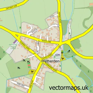
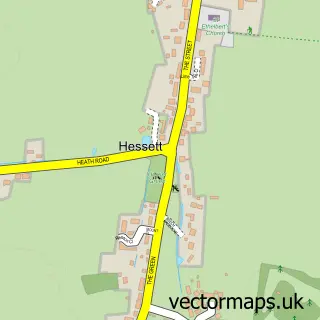
This Woolpit street map is a detailed vector street map covering a 750m x 750m area. Select a larger area to create and download your own vector street map of Woolpit.
The 750-metre map sample for Woolpit covers 375 mapped buildings and approximately 15.6 km of road detail, of which 23 named roads are named. The immediate area includes 1 GP surgery, 1 pub and 1 MOT station, with 3 within 2 miles. The wider area around Woolpit features 4 food and drink venues. To create a larger or custom map of Woolpit, the map builder lets you define your own coverage area and download editable SVG, PDF and PNG files.
Create a larger editable map of Woolpit
Choose any area you need and generate a high-quality vector map instantly. Perfect for print, planning, design, business and personal use.

This Woolpit street map in Suffolk is available as downloadable SVG, PDF and PNG map files, or as a printed map for planning, business, display, education, local information and design work. You can also create a larger custom map area using the map selector.
What this Woolpit map sample shows
Woolpit lies within Woolpit Cp parish, part of Elmswell & Woolpit ward in the Mid Suffolk District local authority area. The postcode geography for this area includes the IP postcode area, the IP30 postcode district and the IP30 9 postcode sector. Residents fall under the Nhs Suffolk And North East Essex Integrated Care Board for NHS services.
Local features near Woolpit
Within 2 milesAmenities and services in and around Woolpit.
Administrative and postcode information for Woolpit
The local authority covering Woolpit is Mid Suffolk District, within the county of Suffolk. The settlement lies within Elmswell & Woolpit ward and Woolpit Cp civil parish. The IP30 postcode district and IP30 9 postcode sector serve the immediate area. NHS provision in the area is delivered through West Suffolk Nhs Foundation Trust.
Nearby street map samples around Woolpit

More street maps in Suffolk
750 metre map area coverage
Boundary, postcode and point of interest information for the 750m x 750m rectangle centred on this sample map.
Boundaries containing map centre
Constituency: Bury St. Edmunds and Stowmarket Co Const
County: Suffolk County
District: Mid Suffolk District
Icb: NHS Essex ICB
Parish: Woolpit CP
Police Force: suffolk
Postcode District: IP30
Postcode Sector: IP30 9
Ward: Elmswell & Woolpit Ward
Nearby boundaries intersecting sample
No additional intersecting boundaries found.
Postcode coverage
POI category counts
Convenience Store: 4
Church Cathedral: 3
Atms: 2
Automotive Repair: 2
Coffee Shop: 2
Driving School: 2
Grocery Store: 2
Post Office: 2
Anglican Church: 1
Beauty And Spa: 1
Sample points of interest
- Woolpit, St Mary
- East of England Co-op WOOLPIT (ERF), Woolpit
- PayPoint
- Taylor Commercial
- Woolpit Garage
- A.N Beauty Rooms
- Sugaring & Beauty by Jill MacDonald
- Goldstar Transport Ltd.
- Green Wolf Cafe
- St Marys Church, Woolpit
- St Marys Church, Woolpit
- St. Mary's Church
Create a larger editable map of Woolpit
This sample shows only a 750 metre area. To create a larger map of Woolpit, use our map builder to choose your own coverage area, add titles and download editable SVG, PDF and PNG files.
Create a custom map of Woolpit