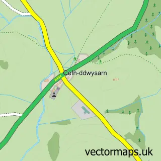
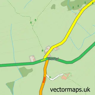
This Y Frongoch street map is a detailed vector street map covering a 750m x 750m area. Select a larger area to create and download your own vector street map of Y Frongoch.
The 750-metre map sample for Y Frongoch covers 59 mapped buildings and approximately 9.5 km of road detail, of which 1 named road are named. The immediate area includes 1 school. The wider area around Y Frongoch features 3 hotels and 2 campsites within 2 miles. To create a larger or custom map of Y Frongoch, the map builder lets you define your own coverage area and download editable SVG, PDF and PNG files.
Create a larger editable map of Y Frongoch
Choose any area you need and generate a high-quality vector map instantly. Perfect for print, planning, design, business and personal use.

This Y Frongoch street map in Gwynedd is available as downloadable SVG, PDF and PNG map files, or as a printed map for planning, business, display, education, local information and design work. You can also create a larger custom map area using the map selector.
What this Y Frongoch map sample shows
Y Frongoch lies within Llandderfel Community parish, part of Llandderfel ward in the Gwynedd - Gwynedd local authority area. The postcode geography for this area includes the LL postcode area, the LL23 postcode district and the LL23 7 postcode sector. Residents fall under the Betsi Cadwaladr University Health Board for NHS services.
Local features near Y Frongoch
Within 2 milesAmenities and services in and around Y Frongoch.
Administrative and postcode information for Y Frongoch
Y Frongoch lies within Llandderfel Community parish, part of Llandderfel ward in the Gwynedd - Gwynedd local authority area. The postcode geography for this area includes the LL postcode area, the LL23 postcode district and the LL23 7 postcode sector. Residents fall under the Betsi Cadwaladr University Health Board for NHS services.
Nearby street map samples around Y Frongoch

More street maps in Gwynedd
750 metre map area coverage
Boundary, postcode and point of interest information for the 750m x 750m rectangle centred on this sample map.
Boundaries containing map centre
Constituency: Dwyfor Meirionnydd Co Const
District: Gwynedd - Gwynedd
Icb: Betsi Cadwaladr University
Parish: Llandderfel Community
Police Force: north wales
Postcode District: LL23
Postcode Sector: LL23 7
Nearby boundaries intersecting sample
Parish: Llanycil Community
Postcode coverage
POI category counts
Hotel: 3
Bed And Breakfast: 1
Elementary School: 1
Hair Salon: 1
Train Station: 1
Transportation: 1
Sample points of interest
- Rhydydefaid Farm B&B
- Ysgol Bro Tryweryn
- G S Hair Design
- Cysgod y Garn
- Tai'r Felin Farm
- The Railway Cottage
- Frongoch railway station
- Dolafon
Create a larger editable map of Y Frongoch
This sample shows only a 750 metre area. To create a larger map of Y Frongoch, use our map builder to choose your own coverage area, add titles and download editable SVG, PDF and PNG files.
Create a custom map of Y Frongoch