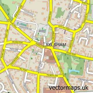
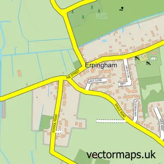
This Aldborough street map is a detailed vector street map covering a 750m x 750m area. Select a larger area to create and download your own vector street map of Aldborough.
The 750-metre map sample for Aldborough covers 171 mapped buildings and approximately 6.5 km of road detail, of which 7 named roads are named. The immediate area includes 1 GP surgery, 2 pubs and 1 MOT station within 2 miles. The wider area around Aldborough features 2 food and drink venues. To create a larger or custom map of Aldborough, the map builder lets you define your own coverage area and download editable SVG, PDF and PNG files.
Create a larger editable map of Aldborough
Choose any area you need and generate a high-quality vector map instantly. Perfect for print, planning, design, business and personal use.

This Aldborough street map in Norfolk is available as downloadable SVG, PDF and PNG map files, or as a printed map for planning, business, display, education, local information and design work. You can also create a larger custom map area using the map selector.
What this Aldborough map sample shows
Aldborough lies within Aldborough & Thurgarton Cp parish, part of Erpingham ward in the North Norfolk District local authority area. The postcode geography for this area includes the NR postcode area, the NR11 postcode district and the NR11 7 postcode sector. Residents fall under the Nhs Norfolk And Waveney Integrated Care Board for NHS services.
Local features near Aldborough
Within 2 milesAmenities and services in and around Aldborough.
Administrative and postcode information for Aldborough
Aldborough lies within Aldborough & Thurgarton Cp parish, part of Erpingham ward in the North Norfolk District local authority area. The postcode geography for this area includes the NR postcode area, the NR11 postcode district and the NR11 7 postcode sector. Residents fall under the Nhs Norfolk And Waveney Integrated Care Board for NHS services.
Nearby street map samples around Aldborough


More street maps in Norfolk
750 metre map area coverage
Boundary, postcode and point of interest information for the 750m x 750m rectangle centred on this sample map.
Boundaries containing map centre
Constituency: North Norfolk Co Const
County: Norfolk County
District: North Norfolk District
Icb: NHS Norfolk and Waveney ICB
Parish: Aldborough & Thurgarton CP
Police Force: norfolk
Postcode District: NR11
Postcode Sector: NR11 7
Ward: Erpingham Ward
Nearby boundaries intersecting sample
Parish: Alby with Thwaite CP
Postcode coverage
POI category counts
Post Office: 2
Pub: 2
Auction House: 1
Building Supply Store: 1
Community Center: 1
Cricket Ground: 1
Doctor: 1
Home Goods Store: 1
Performing Arts: 1
Shipping Center: 1
Sample points of interest
- Knight's Sporting Auctions
- NTrap
- The Church Room
- Aldborough Cricket Club
- Aldborough Surgery
- Jaymic Ltd.
- Heather Tamplin, Norfolk Artist
- Aldborough Post Office
- Post Office
- Black Boys Public House
- The Cricketers on The Green
- Post Office-Aldborough
Create a larger editable map of Aldborough
This sample shows only a 750 metre area. To create a larger map of Aldborough, use our map builder to choose your own coverage area, add titles and download editable SVG, PDF and PNG files.
Create a custom map of Aldborough