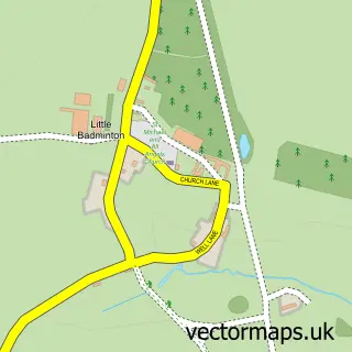
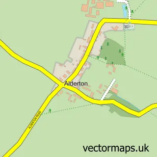
This Badminton street map is a detailed vector street map covering a 750m x 750m area. Select a larger area to create and download your own vector street map of Badminton.
The 750-metre map sample for Badminton covers 73 mapped buildings and approximately 7.9 km of road detail, of which 7 named roads are named. The wider area around Badminton features 2 tourism points of interest. To create a larger or custom map of Badminton, the map builder lets you define your own coverage area and download editable SVG, PDF and PNG files.
Create a larger editable map of Badminton
Choose any area you need and generate a high-quality vector map instantly. Perfect for print, planning, design, business and personal use.

This Badminton street map in Gloucestershire is available as downloadable SVG, PDF and PNG map files, or as a printed map for planning, business, display, education, local information and design work. You can also create a larger custom map area using the map selector.
What this Badminton map sample shows
Badminton lies within Badminton Cp parish, part of Chipping Sodbury & Cotswold Edge ward in the South Gloucestershire local authority area. The postcode geography for this area includes the GL postcode area, the GL9 postcode district and the GL9 1 postcode sector. Residents fall under the Nhs Bristol, North Somerset And South Gloucestershire Integrated Care Board for NHS services.
Local features near Badminton
Within 2 milesAmenities and services in and around Badminton.
Administrative and postcode information for Badminton
Badminton lies within Badminton Cp parish, part of Chipping Sodbury & Cotswold Edge ward in the South Gloucestershire local authority area. The postcode geography for this area includes the GL postcode area, the GL9 postcode district and the GL9 1 postcode sector. Residents fall under the Nhs Bristol, North Somerset And South Gloucestershire Integrated Care Board for NHS services.
Nearby street map samples around Badminton

More street maps in Gloucestershire
750 metre map area coverage
Boundary, postcode and point of interest information for the 750m x 750m rectangle centred on this sample map.
Boundaries containing map centre
Constituency: Thornbury and Yate Co Const
District: South Gloucestershire
Icb: NHS Bristol North Somerset and South Gloucestershire ICB
Parish: Badminton CP
Police Force: avon and somerset
Postcode District: GL9
Postcode Sector: GL9 1
Ward: Chipping Sodbury & Cotswold Edge Ward
Nearby boundaries intersecting sample
No additional intersecting boundaries found.
Postcode coverage
POI category counts
Anglican Church: 1
Campground: 1
Convenience Store: 1
Dog Walkers: 1
Event Planning: 1
Landmark And Historical Building: 1
Pet Sitting: 1
Preschool: 1
Professional Services: 1
Real Estate Agent: 1
Sample points of interest
- St Michael & All Angels
- The Badminton Retreat
- Drewetts Stores
- Muddy Paws Dog Walking Services
- Badminton Estate
- Badminton House
- Duke of Beaufort
- Dragonflies Nursery, Badminton
- Badminton Village Club
- The Somerset Trust
- Somercecil
- Post Office
Create a larger editable map of Badminton
This sample shows only a 750 metre area. To create a larger map of Badminton, use our map builder to choose your own coverage area, add titles and download editable SVG, PDF and PNG files.
Create a custom map of Badminton