Vector Maps logo
Home Why it works Popular maps Districts Samples Customizer Create Your Map
VectorMaps.uk
Home Popular maps Districts Samples Customizer Create Your Map Privacy Disclaimer
Home / UK Maps / Kincardineshire / Banchory Map

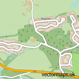
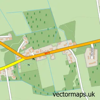
This Banchory street map is a detailed vector street map covering a 750m x 750m area. Select a larger area to create and download your own vector street map of Banchory.

Banchory is a town in Kincardineshire, in the North East Scotland of Scotland. The settlement falls within the West Aberdeenshire And Kincardine parliamentary constituency. It is served by the AB31 postcode district, with AB31 5 as the local postcode sect

The 750-metre map sample for Banchory covers 170 mapped buildings and approximately 20.0 km of road detail, of which 25 named roads are named. The immediate area includes 1 GP surgery and 3 MOT stations within 2 miles. The wider area around Banchory features 2 tourism points of interest, 8 food and drink venues and 4 hotels. To create a larger or custom map of Banchory, the map builder lets you define your own coverage area and download editable SVG, PDF and PNG files.

170Buildings
19.96 kmRoads
25Named roads
0Residents within 2 miles
Create your own

Create a larger editable map of Banchory

Choose any area you need and generate a high-quality vector map instantly. Perfect for print, planning, design, business and personal use.

Choose any location
Editable SVG files
Any size up to A0
PDF, PNG & more
Instant download
High quality guaranteed
Create My Custom Map
Secure, private & no credit card required
Banchory Vector Street Map
750m Sample
Banchory vector street map sample showing roads, buildings and local features in a 750 metre preview area
Buy Banchory Map Print from £12.95 Buy Banchory Digital Map from £6

This Banchory street map in Kincardineshire is available as downloadable SVG, PDF and PNG map files, or as a printed map for planning, business, display, education, local information and design work. You can also create a larger custom map area using the map selector.

What this Banchory map sample shows

Banchory lies within Aberdeenshire parish, part of Banchory And Mid Deeside ward in the Aberdeenshire local authority area. The postcode geography for this area includes the AB postcode area, the AB31 postcode district and the AB31 5 postcode sector. Residents fall under the Grampian for NHS services.

Local features near Banchory

Within 2 miles

Amenities and services in and around Banchory.

1 Campsites within 2 miles
1 GP surgeries 1 within 2 miles
3 MOT stations within 2 miles
2 Tourism & leisure
8 Food & drink
4 Hotels
3 Healthcare POIs
2 Vehicle services

Counts are approximate and based on publicly available data.

Administrative and postcode information for Banchory

The local authority covering Banchory is Aberdeenshire, within the county of Kincardineshire. The settlement lies within Banchory And Mid Deeside ward and Aberdeenshire civil parish. The AB31 postcode district and AB31 5 postcode sector serve the immediate area. NHS provision in the area is delivered through Grampian.

Parish ABERDEENSHIRE
Ward Banchory and Mid Deeside
District / local authority Aberdeenshire
County Kincardineshire
Historic county Kincardineshire
Postcode district AB31
Postcode sector AB31 5
Parliamentary constituency West Aberdeenshire and Kincardine
Region North East Scotland
Country Scotland

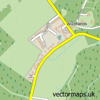
Nearby street map samples around Banchory

Street map sample of Aberdeen, City of Aberdeen Aberdeen City - City of Aberdeen - 16.8 miles Street map sample of Inchmarlo, Kincardineshire Inchmarlo Village - Kincardineshire - 1.6 miles Street map sample of Strachan, Kincardineshire Strachan Village - Kincardineshire - 2.5 miles Street map sample of Crathes, Kincardineshire Crathes Village - Kincardineshire - 3.4 miles Street map sample of Kirkton of Durris, Kincardineshire Kirkton of Durris Village - Kincardineshire - 4.8 miles Street map sample of Finzean, Aberdeenshire Finzean Village - Aberdeenshire - 5.1 miles Street map sample of Woodlands of Durris, Kincardineshire Woodlands of Durris Village - Kincardineshire - 5.8 miles Street map sample of Torphins, Aberdeenshire Torphins Village - Aberdeenshire - 5.8 miles Street map sample of Park, Aberdeenshire Park Village - Aberdeenshire - 5.9 miles Street map sample of Drumoak, Aberdeenshire Drumoak Village - Aberdeenshire - 6.3 miles

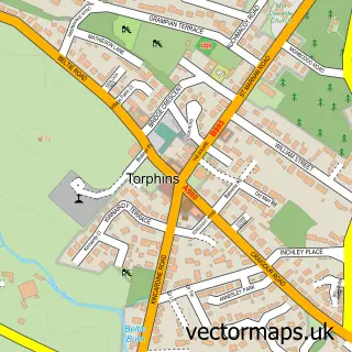
More street maps in Kincardineshire

Street map sample of Inchmarlo, Kincardineshire Inchmarlo Village - 1.6 miles Street map sample of Strachan, Kincardineshire Strachan Village - 2.5 miles Street map sample of Crathes, Kincardineshire Crathes Village - 3.4 miles Street map sample of Kirkton of Durris, Kincardineshire Kirkton of Durris Village - 4.8 miles Street map sample of Woodlands of Durris, Kincardineshire Woodlands of Durris Village - 5.8 miles

750 metre map area coverage

Boundary, postcode and point of interest information for the 750m x 750m rectangle centred on this sample map.

Boundaries containing map centre

Constituency: West Aberdeenshire and Kincardine Co Const

District: Aberdeenshire

Icb: Grampian

Postcode District: AB31

Postcode Sector: AB31 5

Ward: Banchory and Mid Deeside Ward

Nearby boundaries intersecting sample

Postcode Sector: AB31 6

Postcode coverage

AB31 AB31 5 AB31 6

POI category counts

Barber: 8

Beauty Salon: 8

Accountant: 6

Community Services Non Profits: 5

Banks: 4

Flowers And Gifts Shop: 4

Hair Salon: 4

Hotel: 4

Professional Services: 4

Arts And Crafts: 3

Sample points of interest

  • Aberdein Considine Accountant
  • BBKS & Co. Accountant
  • Grant Considine Accountant
  • Grant Considine, Chartered Accountants Accountant
  • TaxAssist Accountants Accountant
  • The Grant Considine Partnership Accountant
  • British Red Cross Antique Store
  • Fiddes Architects Architectural Designer
  • Banchory Arts and Crafts Market Arts And Crafts
  • Meg's Attic - Craft Supplies Arts And Crafts
  • Studio 1 Arts And Crafts
  • Rangoli Banchory Asian Fusion Restaurant

Create a larger editable map of Banchory

This sample shows only a 750 metre area. To create a larger map of Banchory, use our map builder to choose your own coverage area, add titles and download editable SVG, PDF and PNG files.

Create a custom map of Banchory

Phone 01751 473136 | Copyright Vectormaps.uk 2026

Samples Customizer Privacy Disclaimer
Banchory Vector Street Map
Banchory enlarged street map sample showing a 750 metre preview area