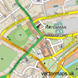
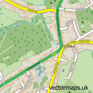
This Betws street map is a detailed vector street map covering a 750m x 750m area. Select a larger area to create and download your own vector street map of Betws.
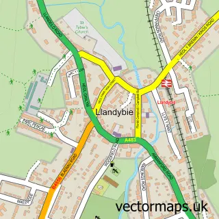
The 750-metre map sample for Betws covers 333 mapped buildings and approximately 14.4 km of road detail, of which 23 named roads are named. The immediate area includes 1 school, 1 GP surgery within 2 miles, 4 pubs and 1 MOT station, with 5 within 2 miles. The wider area around Betws features 3 tourism points of interest and 7 food and drink venues. To create a larger or custom map of Betws, the map builder lets you define your own coverage area and download editable SVG, PDF and PNG files.
Create a larger editable map of Betws
Choose any area you need and generate a high-quality vector map instantly. Perfect for print, planning, design, business and personal use.

This Betws street map in Dyfed is available as downloadable SVG, PDF and PNG map files, or as a printed map for planning, business, display, education, local information and design work. You can also create a larger custom map area using the map selector.
What this Betws map sample shows
Betws lies within Betws Community parish, part of Betws ward in the Sir Gaerfyrddin - Carmarthenshire local authority area. The postcode geography for this area includes the SA postcode area, the SA18 postcode district and the SA18 2 postcode sector. Residents fall under the Hywel Dda University Health Board for NHS services.
Local features near Betws
Within 2 milesAmenities and services in and around Betws.
Administrative and postcode information for Betws
Betws lies within Betws Community parish, part of Betws ward in the Sir Gaerfyrddin - Carmarthenshire local authority area. The postcode geography for this area includes the SA postcode area, the SA18 postcode district and the SA18 2 postcode sector. Residents fall under the Hywel Dda University Health Board for NHS services.
Nearby street map samples around Betws

More street maps in Dyfed
750 metre map area coverage
Boundary, postcode and point of interest information for the 750m x 750m rectangle centred on this sample map.
Boundaries containing map centre
Constituency: Caerfyrddin Co Const
District: Sir Gaerfyrddin - Carmarthenshire
Icb: Hywel Dda
Parish: Betws Community
Police Force: dyfed-powys
Postcode District: SA18
Postcode Sector: SA18 2
Nearby boundaries intersecting sample
Parish: Ammanford Community
Postcode Sector: SA18 3
Postcode coverage
POI category counts
Professional Services: 5
Supermarket: 5
Beauty Salon: 4
Pub: 4
Automotive Repair: 3
Passport And Visa Services: 3
Rental Kiosks: 3
Screen Printing T Shirt Printing: 3
Advertising Agency: 2
Banks: 2
Sample points of interest
- Agf X
- Autograffeg
- Stardust Amusements
- C R Clarke & Co
- Anthony Richards Fine Art
- The Gallery
- L.E auto detailing
- Al’s Auto Services
- Ng-motorworx ltd
- One Stop Check
- NatWest Mobile Branch
- Nationwide Building Society
Create a larger editable map of Betws
This sample shows only a 750 metre area. To create a larger map of Betws, use our map builder to choose your own coverage area, add titles and download editable SVG, PDF and PNG files.
Create a custom map of Betws