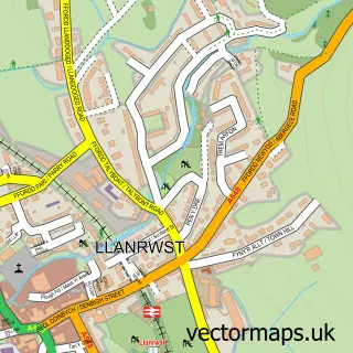
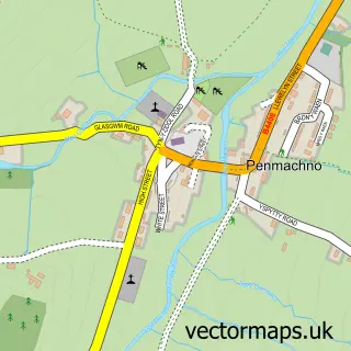
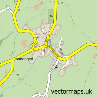
This Betws-y-coed street map is a detailed vector street map covering a 750m x 750m area. Select a larger area to create and download your own vector street map of Betws-y-coed.
The 750-metre map sample for Betws-y-coed covers 108 mapped buildings and approximately 10.7 km of road detail, of which 5 named roads are named. The immediate area includes 1 railway station, 2 pubs and 1 MOT station. The wider area around Betws-y-coed features 15 tourism points of interest, 11 food and drink venues and 15 hotels. To create a larger or custom map of Betws-y-coed, the map builder lets you define your own coverage area and download editable SVG, PDF and PNG files.
Create a larger editable map of Betws-y-coed
Choose any area you need and generate a high-quality vector map instantly. Perfect for print, planning, design, business and personal use.

This Betws-y-coed street map in Clwyd is available as downloadable SVG, PDF and PNG map files, or as a printed map for planning, business, display, education, local information and design work. You can also create a larger custom map area using the map selector.
What this Betws-y-coed map sample shows
Betws-y-coed lies within Betws-Y-Coed Community parish, part of Betws-Y-Coed ward in the Conwy - Conwy local authority area. The postcode geography for this area includes the LL postcode area, the LL24 postcode district and the LL24 0 postcode sector. Residents fall under the Betsi Cadwaladr University Health Board for NHS services.
Local features near Betws-y-coed
Within 2 milesAmenities and services in and around Betws-y-coed.
Administrative and postcode information for Betws-y-coed
Betws-y-coed lies within Betws-Y-Coed Community parish, part of Betws-Y-Coed ward in the Conwy - Conwy local authority area. The postcode geography for this area includes the LL postcode area, the LL24 postcode district and the LL24 0 postcode sector. Residents fall under the Betsi Cadwaladr University Health Board for NHS services.
Nearby street map samples around Betws-y-coed

More street maps in Clwyd
750 metre map area coverage
Boundary, postcode and point of interest information for the 750m x 750m rectangle centred on this sample map.
Boundaries containing map centre
Constituency: Bangor Aberconwy Co Const
District: Conwy - Conwy
Icb: Betsi Cadwaladr University
Parish: Betws-y-Coed Community
Police Force: north wales
Postcode District: LL24
Postcode Sector: LL24 0
Nearby boundaries intersecting sample
Parish: Bro Garmon Community
Postcode coverage
POI category counts
Bed And Breakfast: 17
Hotel: 14
Outdoor Gear: 10
Clothing Store: 6
Hostel: 6
Park: 5
Cafe: 4
Convenience Store: 4
Pet Store: 4
Church Cathedral: 3
Sample points of interest
- The Nook at Garden Cottage, Coed y Celyn
- Galeri Betws-y-Coed
- Jacha Potgieter - Oriel Ospie
- Artworks 2 Celf
- Find Me Knitting
- Pont-Y-Pair Falls
- Seren Ventures
- Bettws-Y-Coed Motors
- HSBC Bank
- Wrth y bar, y Stablau, Betws y Coed
- Y Stablau - Stables Bar
- Grill Room
Create a larger editable map of Betws-y-coed
This sample shows only a 750 metre area. To create a larger map of Betws-y-coed, use our map builder to choose your own coverage area, add titles and download editable SVG, PDF and PNG files.
Create a custom map of Betws-y-coed