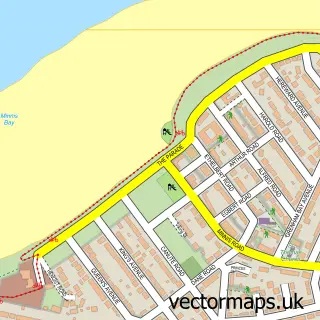
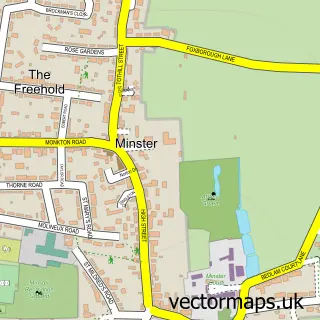
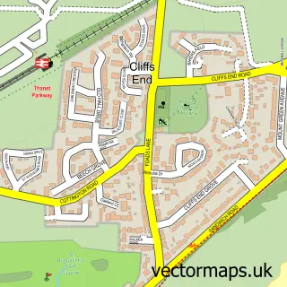
This Birchington street map is a detailed vector street map covering a 750m x 750m area. Select a larger area to create and download your own vector street map of Birchington.
The 750-metre map sample for Birchington covers 562 mapped buildings and approximately 20.7 km of road detail, of which 50 named roads are named. The immediate area includes 2 GP surgeries within 2 miles, 6 pubs and 1 MOT station, with 3 within 2 miles. The wider area around Birchington features 3 tourism points of interest, 17 food and drink venues and 2 hotels. To create a larger or custom map of Birchington, the map builder lets you define your own coverage area and download editable SVG, PDF and PNG files.
Create a larger editable map of Birchington
Choose any area you need and generate a high-quality vector map instantly. Perfect for print, planning, design, business and personal use.

This Birchington street map in Kent is available as downloadable SVG, PDF and PNG map files, or as a printed map for planning, business, display, education, local information and design work. You can also create a larger custom map area using the map selector.
What this Birchington map sample shows
Birchington lies within Birchington Cp parish, part of Birchington North ward in the Thanet District local authority area. The postcode geography for this area includes the CT postcode area, the CT7 postcode district and the CT7 9 postcode sector. Residents fall under the Nhs Kent And Medway Integrated Care Board for NHS services.
Local features near Birchington
Within 2 milesAmenities and services in and around Birchington.
Administrative and postcode information for Birchington
The local authority covering Birchington is Thanet District, within the county of Kent. The settlement lies within Birchington North ward and Birchington Cp civil parish. The CT7 postcode district and CT7 9 postcode sector serve the immediate area. NHS provision in the area is delivered through East Kent Hospitals University Nhs Foundation Trust.
Nearby street map samples around Birchington

More street maps in Kent
750 metre map area coverage
Boundary, postcode and point of interest information for the 750m x 750m rectangle centred on this sample map.
Boundaries containing map centre
Constituency: Herne Bay and Sandwich Co Const
County: Kent County
District: Thanet District
Icb: NHS Kent and Medway ICB
Parish: Birchington CP
Police Force: kent
Postcode District: CT7
Postcode Sector: CT7 9
Ward: Birchington South Ward
Nearby boundaries intersecting sample
Postcode Sector: CT7 0
Postcode coverage
POI category counts
Hair Salon: 9
Real Estate Agent: 8
Convenience Store: 7
Pub: 6
Barber: 5
Banks: 4
Building Supply Store: 4
Cafe: 4
Flowers And Gifts Shop: 4
Restaurant: 4
Sample points of interest
- Birchington Holistic Centre
- The Meditation Trust
- All Saints Church
- RSPCA
- Minnis Bay Hidden Treasures
- The Jewellery And antiques shop
- Isolin H G
- The Cooperative Food Birchington - Station Road
- Eagle Security Systems
- L & G Mortgage Solutions
- Birchington Auto Repairs
- Station Garage
Create a larger editable map of Birchington
This sample shows only a 750 metre area. To create a larger map of Birchington, use our map builder to choose your own coverage area, add titles and download editable SVG, PDF and PNG files.
Create a custom map of Birchington