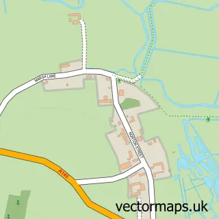
This Brancaster street map is a detailed vector street map covering a 750m x 750m area. Select a larger area to create and download your own vector street map of Brancaster.
The 750-metre map sample for Brancaster covers 251 mapped buildings and approximately 14.2 km of road detail, of which 13 named roads are named. The immediate area includes 1 pub and 1 MOT station. The wider area around Brancaster features 1 food and drink venue, 1 hotel and 1 campsite within 2 miles. To create a larger or custom map of Brancaster, the map builder lets you define your own coverage area and download editable SVG, PDF and PNG files.
Create a larger editable map of Brancaster
Choose any area you need and generate a high-quality vector map instantly. Perfect for print, planning, design, business and personal use.

This Brancaster street map in Norfolk is available as downloadable SVG, PDF and PNG map files, or as a printed map for planning, business, display, education, local information and design work. You can also create a larger custom map area using the map selector.
What this Brancaster map sample shows
Brancaster lies within Brancaster Cp parish, part of Brancaster ward in the King's Lynn And West Norfolk District (B) local authority area. The postcode geography for this area includes the PE postcode area, the PE31 postcode district and the PE31 8 postcode sector. Residents fall under the Nhs Norfolk And Waveney Integrated Care Board for NHS services.
Local features near Brancaster
Within 2 milesAmenities and services in and around Brancaster.
Administrative and postcode information for Brancaster
Brancaster lies within Brancaster Cp parish, part of Brancaster ward in the King's Lynn And West Norfolk District (B) local authority area. The postcode geography for this area includes the PE postcode area, the PE31 postcode district and the PE31 8 postcode sector. Residents fall under the Nhs Norfolk And Waveney Integrated Care Board for NHS services.
Nearby street map samples around Brancaster


More street maps in Norfolk
750 metre map area coverage
Boundary, postcode and point of interest information for the 750m x 750m rectangle centred on this sample map.
Boundaries containing map centre
Constituency: North West Norfolk Co Const
County: Norfolk County
District: King's Lynn and West Norfolk District (B)
Icb: NHS Norfolk and Waveney ICB
Parish: Brancaster CP
Police Force: norfolk
Postcode District: PE31
Postcode Sector: PE31 8
Ward: Brancaster Ward
Nearby boundaries intersecting sample
No additional intersecting boundaries found.
Postcode coverage
POI category counts
Holiday Rental Home: 3
Anglican Church: 1
Building Supply Store: 1
Cabin: 1
Church Cathedral: 1
Elementary School: 1
Hotel: 1
Ice Cream And Frozen Yoghurt: 1
Pub: 1
Real Estate Agent: 1
Sample points of interest
- St Mary the Virgin, Brancaster
- Norman Raynore
- T F Marketing
- Saint Mary the Virgin
- Brancaster Primary School
- Duffields Brancaster
- Dune House Brancaster
- Rosa Cottage, Brancaster
- The Ship Hotel, Brancaster
- Brancaster Beach Kiosk
- 71 Club
- Norfolk Coastal Home Search
Create a larger editable map of Brancaster
This sample shows only a 750 metre area. To create a larger map of Brancaster, use our map builder to choose your own coverage area, add titles and download editable SVG, PDF and PNG files.
Create a custom map of Brancaster