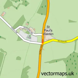
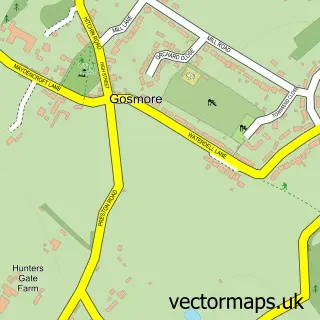
This Breachwood Green street map is a detailed vector street map covering a 750m x 750m area. Select a larger area to create and download your own vector street map of Breachwood Green.
The 750-metre map sample for Breachwood Green covers 162 mapped buildings and approximately 7.8 km of road detail, of which 11 named roads are named. The immediate area includes 1 school, 1 GP surgery within 2 miles and 1 pub. The wider area around Breachwood Green features 1 food and drink venue. To create a larger or custom map of Breachwood Green, the map builder lets you define your own coverage area and download editable SVG, PDF and PNG files.
Create a larger editable map of Breachwood Green
Choose any area you need and generate a high-quality vector map instantly. Perfect for print, planning, design, business and personal use.

This Breachwood Green street map in Hertfordshire is available as downloadable SVG, PDF and PNG map files, or as a printed map for planning, business, display, education, local information and design work. You can also create a larger custom map area using the map selector.
What this Breachwood Green map sample shows
Breachwood Green lies within King's Walden Cp parish, part of Hitchwood, Offa And Hoo ward in the North Hertfordshire District local authority area. The postcode geography for this area includes the SG postcode area, the SG4 postcode district and the SG4 8 postcode sector. Residents fall under the Nhs Hertfordshire And West Essex Integrated Care Board for NHS services.
Local features near Breachwood Green
Within 2 milesAmenities and services in and around Breachwood Green.
Administrative and postcode information for Breachwood Green
The local authority covering Breachwood Green is North Hertfordshire District, within the county of Hertfordshire. The settlement lies within Hitchwood, Offa And Hoo ward and King's Walden Cp civil parish. The SG4 postcode district and SG4 8 postcode sector serve the immediate area. NHS provision in the area is delivered through East And North Hertfordshire Nhs Trust.
Nearby street map samples around Breachwood Green

More street maps in Hertfordshire
750 metre map area coverage
Boundary, postcode and point of interest information for the 750m x 750m rectangle centred on this sample map.
Boundaries containing map centre
Constituency: Hitchin Co Const
County: Hertfordshire County
District: North Hertfordshire District
Icb: NHS Central East ICB
Parish: King's Walden CP
Police Force: hertfordshire
Postcode District: SG4
Postcode Sector: SG4 8
Ward: Hitchwood Ward
Nearby boundaries intersecting sample
No additional intersecting boundaries found.
Postcode coverage
POI category counts
Elementary School: 2
Preschool: 2
Architectural Designer: 1
Beauty And Spa: 1
Building Contractor: 1
Business Consulting: 1
Charity Organization: 1
Community Center: 1
Computer Store: 1
Construction Services: 1
Sample points of interest
- AAC Design
- Mhy Beauty & Aesthetics by Nikki
- A A C House Extension Design
- Self Build Project Management
- Transitions UK
- Breachwood Green Village Hall
- Home Computer Services
- Amcell Building Co. Ltd
- Galliers Plastering
- The British Rat Pack
- Breachwood Green County Primary School
- Breachwood Green Junior Mixed and Infant School
Create a larger editable map of Breachwood Green
This sample shows only a 750 metre area. To create a larger map of Breachwood Green, use our map builder to choose your own coverage area, add titles and download editable SVG, PDF and PNG files.
Create a custom map of Breachwood Green