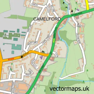
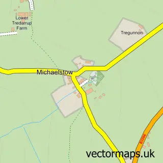
This Delabole street map is a detailed vector street map covering a 750m x 750m area. Select a larger area to create and download your own vector street map of Delabole.
The 750-metre map sample for Delabole covers 310 mapped buildings and approximately 10.5 km of road detail, of which 16 named roads are named. The immediate area includes 1 school, 1 pub and 1 MOT station within 2 miles. The wider area around Delabole features 1 tourism point of interest, 1 food and drink venue and 2 campsites within 2 miles. To create a larger or custom map of Delabole, the map builder lets you define your own coverage area and download editable SVG, PDF and PNG files.
Create a larger editable map of Delabole
Choose any area you need and generate a high-quality vector map instantly. Perfect for print, planning, design, business and personal use.

This Delabole street map in Cornwall is available as downloadable SVG, PDF and PNG map files, or as a printed map for planning, business, display, education, local information and design work. You can also create a larger custom map area using the map selector.
What this Delabole map sample shows
Delabole lies within Delabole Cp parish, part of St Teath And St Breward ward in the Cornwall local authority area. The postcode geography for this area includes the PL postcode area, the PL33 postcode district and the PL33 9 postcode sector. Residents fall under the Nhs Cornwall And The Isles Of Scilly Integrated Care Board for NHS services.
Local features near Delabole
Within 2 milesAmenities and services in and around Delabole.
Administrative and postcode information for Delabole
The local authority covering Delabole is Cornwall, within the county of Cornwall. The settlement lies within St Teath And St Breward ward and Delabole Cp civil parish. The PL33 postcode district and PL33 9 postcode sector serve the immediate area. NHS provision in the area is delivered through Royal Cornwall Hospitals Nhs Trust.
Nearby street map samples around Delabole

More street maps in Cornwall
750 metre map area coverage
Boundary, postcode and point of interest information for the 750m x 750m rectangle centred on this sample map.
Boundaries containing map centre
Constituency: North Cornwall Co Const
District: Cornwall
Icb: NHS Cornwall and the Isles of Scilly ICB
Parish: Delabole CP
Police Force: devon and cornwall
Postcode District: PL33
Postcode Sector: PL33 9
Nearby boundaries intersecting sample
Parish: Tintagel CP
Postcode coverage
POI category counts
Church Cathedral: 2
Convenience Store: 2
Doctor: 2
Naturopathic Holistic: 2
Pest Control Service: 2
Preschool: 2
Tattoo And Piercing: 2
Anglican Church: 1
Art Gallery: 1
Auto Electrical Repair: 1
Sample points of interest
- Delabole: St John the Evangelist
- Unit T8
- Ivan Jones Electrical Services
- Hair Heaven
- Western Supply
- M and R Motors
- CGH Carpentry and Painting
- St John's Church
- Tintagel Methodist Church
- Mark Irwin & Son Construction
- Take a Fence
- Delabole Stores
Create a larger editable map of Delabole
This sample shows only a 750 metre area. To create a larger map of Delabole, use our map builder to choose your own coverage area, add titles and download editable SVG, PDF and PNG files.
Create a custom map of Delabole