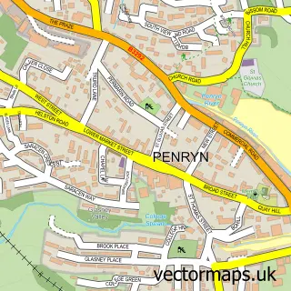
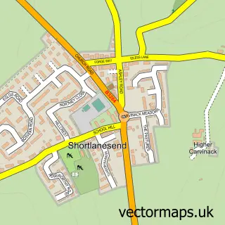
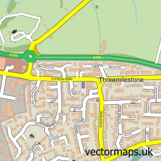
This Truro street map is a detailed vector street map covering a 750m x 750m area. Select a larger area to create and download your own vector street map of Truro.
The 750-metre map sample for Truro covers 269 mapped buildings and approximately 23.3 km of road detail, of which 62 named roads are named. The immediate area includes 3 GP surgeries, 18 pubs and 1 MOT station, with 7 within 2 miles. The wider area around Truro features 3 tourism points of interest, 90 food and drink venues and 3 hotels. To create a larger or custom map of Truro, the map builder lets you define your own coverage area and download editable SVG, PDF and PNG files.
Create a larger editable map of Truro
Choose any area you need and generate a high-quality vector map instantly. Perfect for print, planning, design, business and personal use.

This Truro street map in Cornwall is available as downloadable SVG, PDF and PNG map files, or as a printed map for planning, business, display, education, local information and design work. You can also create a larger custom map area using the map selector.
What this Truro map sample shows
Truro lies within Truro Cp parish, part of Truro Trehaverne ward in the Cornwall local authority area. The postcode geography for this area includes the TR postcode area, the TR1 postcode district and the TR1 3 postcode sector. Residents fall under the Nhs Cornwall And The Isles Of Scilly Integrated Care Board for NHS services.
Local features near Truro
Within 2 milesAmenities and services in and around Truro.
Administrative and postcode information for Truro
The local authority covering Truro is Cornwall, within the county of Cornwall. The settlement lies within Truro Trehaverne ward and Truro Cp civil parish. The TR1 postcode district and TR1 3 postcode sector serve the immediate area. NHS provision in the area is delivered through Royal Cornwall Hospitals Nhs Trust.
Nearby street map samples around Truro
More street maps in Cornwall
750 metre map area coverage
Boundary, postcode and point of interest information for the 750m x 750m rectangle centred on this sample map.
Boundaries containing map centre
Constituency: Truro and Falmouth Co Const
District: Cornwall
Icb: NHS Cornwall and the Isles of Scilly ICB
Parish: Truro CP
Police Force: devon and cornwall
Postcode District: TR1
Postcode Sector: TR1 2
Nearby boundaries intersecting sample
Postcode Sector: TR1 1, TR1 3
Postcode coverage
POI category counts
Clothing Store: 44
Professional Services: 38
Cafe: 34
Hair Salon: 29
Beauty Salon: 27
Employment Agencies: 23
Jewelry Store: 21
Real Estate Agent: 21
Flowers And Gifts Shop: 20
Restaurant: 20
Sample points of interest
- Ashtons
- BK Plus
- Balme Kitchen & Pearce Ltd
- Blackwell Goldsworthy and Co
- Hippo Business Services
- John Savage Accountancy
- Lang Bennetts
- Morlaix' Chartered Financial Planners
- P S May & Co Tax Advisers & Accountants
- Richard J Smith & Co.
- Cornwall Sport
- Player Ready VR Arcade Cornwall
Create a larger editable map of Truro
This sample shows only a 750 metre area. To create a larger map of Truro, use our map builder to choose your own coverage area, add titles and download editable SVG, PDF and PNG files.
Create a custom map of Truro