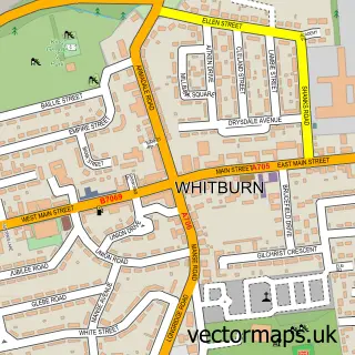
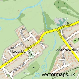
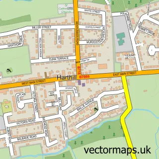
This East Whitburn street map is a detailed vector street map covering a 750m x 750m area. Select a larger area to create and download your own vector street map of East Whitburn.
The 750-metre map sample for East Whitburn covers 259 mapped buildings and approximately 13.6 km of road detail, of which 17 named roads are named. The immediate area includes 2 GP surgeries within 2 miles and 16 MOT stations within 2 miles. The wider area around East Whitburn features 2 tourism points of interest. To create a larger or custom map of East Whitburn, the map builder lets you define your own coverage area and download editable SVG, PDF and PNG files.
Create a larger editable map of East Whitburn
Choose any area you need and generate a high-quality vector map instantly. Perfect for print, planning, design, business and personal use.

This East Whitburn street map in West Lothian is available as downloadable SVG, PDF and PNG map files, or as a printed map for planning, business, display, education, local information and design work. You can also create a larger custom map area using the map selector.
What this East Whitburn map sample shows
East Whitburn lies within West Lothian parish, part of Whitburn And Blackburn ward in the West Lothian local authority area. The postcode geography for this area includes the EH postcode area, the EH47 postcode district and the EH47 8 postcode sector. Residents fall under the Lothian for NHS services.
Local features near East Whitburn
Within 2 milesAmenities and services in and around East Whitburn.
Administrative and postcode information for East Whitburn
The local authority covering East Whitburn is West Lothian, within the county of West Lothian. The settlement lies within Whitburn And Blackburn ward and West Lothian civil parish. The EH47 postcode district and EH47 8 postcode sector serve the immediate area. NHS provision in the area is delivered through Lothian.
Nearby street map samples around East Whitburn

More street maps in West Lothian
750 metre map area coverage
Boundary, postcode and point of interest information for the 750m x 750m rectangle centred on this sample map.
Boundaries containing map centre
Constituency: Bathgate and Linlithgow Co Const
District: West Lothian
Icb: Lothian
Postcode District: EH47
Postcode Sector: EH47 0
Ward: Whitburn and Blackburn Ward
Nearby boundaries intersecting sample
Postcode District: EH48
Postcode Sector: EH47 7, EH47 8, EH48 2
Postcode coverage
POI category counts
Park: 2
Beauty Salon: 1
Car Window Tinting: 1
Carpet Cleaning: 1
Community Center: 1
Convenience Store: 1
Dairy Stores: 1
Dog Walkers: 1
Fast Food Restaurant: 1
Financial Service: 1
Sample points of interest
- Hairport Hair and Make up Studio
- Tint devilz
- Dirtbusters Carpet Cleaning
- East Whitburn Community Education Centre
- Day-Today
- Robert Wiseman & Sons
- Pawppy Power Dog Walking
- Royal bites Whitburn
- Forrest & Associates
- Evri ParcelShop
- Window Shine
- East Whitburn Karate
Create a larger editable map of East Whitburn
This sample shows only a 750 metre area. To create a larger map of East Whitburn, use our map builder to choose your own coverage area, add titles and download editable SVG, PDF and PNG files.
Create a custom map of East Whitburn