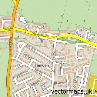
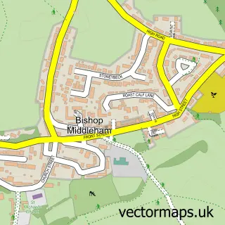
This Fishburn street map is a detailed vector street map covering a 750m x 750m area. Select a larger area to create and download your own vector street map of Fishburn.
The 750-metre map sample for Fishburn covers 369 mapped buildings and approximately 16.0 km of road detail, of which 24 named roads are named. The immediate area includes 1 school, 2 pubs and 2 MOT stations. The wider area around Fishburn features 3 food and drink venues and 1 campsite within 2 miles. To create a larger or custom map of Fishburn, the map builder lets you define your own coverage area and download editable SVG, PDF and PNG files.
Create a larger editable map of Fishburn
Choose any area you need and generate a high-quality vector map instantly. Perfect for print, planning, design, business and personal use.

This Fishburn street map in Durham is available as downloadable SVG, PDF and PNG map files, or as a printed map for planning, business, display, education, local information and design work. You can also create a larger custom map area using the map selector.
What this Fishburn map sample shows
Fishburn lies within Fishburn Cp parish, part of Sedgefield ward in the County Durham local authority area. The postcode geography for this area includes the TS postcode area, the TS21 postcode district and the TS21 4 postcode sector. Residents fall under the Nhs North East And North Cumbria Integrated Care Board for NHS services.
Local features near Fishburn
Within 2 milesAmenities and services in and around Fishburn.
Administrative and postcode information for Fishburn
Fishburn lies within Fishburn Cp parish, part of Sedgefield ward in the County Durham local authority area. The postcode geography for this area includes the TS postcode area, the TS21 postcode district and the TS21 4 postcode sector. Residents fall under the Nhs North East And North Cumbria Integrated Care Board for NHS services.
Nearby street map samples around Fishburn


More street maps in Durham
750 metre map area coverage
Boundary, postcode and point of interest information for the 750m x 750m rectangle centred on this sample map.
Boundaries containing map centre
Constituency: Newton Aycliffe and Spennymoor Co Const
District: County Durham
Icb: NHS North East and North Cumbria ICB
Parish: Fishburn CP
Police Force: durham
Postcode District: TS21
Postcode Sector: TS21 4
Nearby boundaries intersecting sample
No additional intersecting boundaries found.
Postcode coverage
POI category counts
Beauty Salon: 4
Contractor: 4
Atms: 2
Barber: 2
Convenience Store: 2
Gym: 2
Hair Salon: 2
Information Technology Company: 2
Pharmacy: 2
Pizza Restaurant: 2
Sample points of interest
- Snowbird Centre
- St Catherine's Church, Fishburn
- Go Local (ATMaaS)
- The Cooperative Food (BF) Fishburn, Fishburn
- Timeless Auto Trim
- Peter Cathedral Bakers
- Adam's Barbershop
- The Barber Club
- Faye Holly Aesthetics
- Nails & Beauty By Megan
- Natalie Bowes Hairdressing
- North Star Aesthetics
Create a larger editable map of Fishburn
This sample shows only a 750 metre area. To create a larger map of Fishburn, use our map builder to choose your own coverage area, add titles and download editable SVG, PDF and PNG files.
Create a custom map of Fishburn