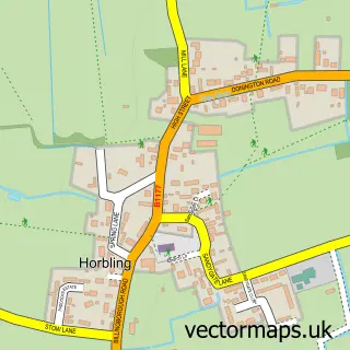
This Folkingham street map is a detailed vector street map covering a 750m x 750m area. Select a larger area to create and download your own vector street map of Folkingham.
The 750-metre map sample for Folkingham covers 212 mapped buildings and approximately 9.1 km of road detail, of which 12 named roads are named. The immediate area includes 1 pub. The wider area around Folkingham features 1 tourism point of interest, 2 food and drink venues and 1 hotel. To create a larger or custom map of Folkingham, the map builder lets you define your own coverage area and download editable SVG, PDF and PNG files.
Create a larger editable map of Folkingham
Choose any area you need and generate a high-quality vector map instantly. Perfect for print, planning, design, business and personal use.

This Folkingham street map in Lincolnshire is available as downloadable SVG, PDF and PNG map files, or as a printed map for planning, business, display, education, local information and design work. You can also create a larger custom map area using the map selector.
What this Folkingham map sample shows
Folkingham lies within Folkingham Cp parish, part of Toller ward in the South Kesteven District local authority area. The postcode geography for this area includes the NG postcode area, the NG34 postcode district and the NG34 0 postcode sector. Residents fall under the Nhs Lincolnshire Integrated Care Board for NHS services.
Local features near Folkingham
Within 2 milesAmenities and services in and around Folkingham.
Administrative and postcode information for Folkingham
Folkingham lies within Folkingham Cp parish, part of Toller ward in the South Kesteven District local authority area. The postcode geography for this area includes the NG postcode area, the NG34 postcode district and the NG34 0 postcode sector. Residents fall under the Nhs Lincolnshire Integrated Care Board for NHS services.
Nearby street map samples around Folkingham

More street maps in Lincolnshire
750 metre map area coverage
Boundary, postcode and point of interest information for the 750m x 750m rectangle centred on this sample map.
Boundaries containing map centre
Constituency: Grantham and Bourne Co Const
County: Lincolnshire County
District: South Kesteven District
Icb: NHS Lincolnshire ICB
Parish: Folkingham CP
Police Force: lincolnshire
Postcode District: NG34
Postcode Sector: NG34 0
Ward: Toller Ward
Nearby boundaries intersecting sample
District: North Kesteven District
Parish: Walcot Near Folkingham CP
Ward: Helpringham & Osbournby Ward
Postcode coverage
POI category counts
Anglican Church: 2
Bed And Breakfast: 2
Financial Service: 2
Post Office: 2
Art School: 1
Automotive Services And Repair: 1
Beauty Salon: 1
Bookstore: 1
Cafe: 1
Castle: 1
Sample points of interest
- St Andrew - Folkingham
- St Andrew's Church
- Folkingham Creative Arts Limited
- VOLLAND Cellar Cooling
- The Aesthetics Room By Katie
- The Barn
- The White House
- Little Duck Books
- The KofeeBox
- Folkingham Castle
- Home Sweep Homes
- Liquiscreed ltd
Create a larger editable map of Folkingham
This sample shows only a 750 metre area. To create a larger map of Folkingham, use our map builder to choose your own coverage area, add titles and download editable SVG, PDF and PNG files.
Create a custom map of Folkingham