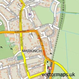
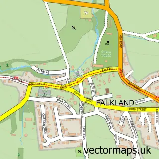
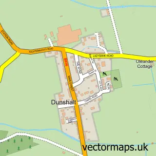
This Freuchie street map is a detailed vector street map covering a 750m x 750m area. Select a larger area to create and download your own vector street map of Freuchie.
The 750-metre map sample for Freuchie covers 152 mapped buildings and approximately 14.5 km of road detail, of which 19 named roads are named. The immediate area includes 1 pub. The wider area around Freuchie features 1 food and drink venue and 1 hotel. To create a larger or custom map of Freuchie, the map builder lets you define your own coverage area and download editable SVG, PDF and PNG files.
Create a larger editable map of Freuchie
Choose any area you need and generate a high-quality vector map instantly. Perfect for print, planning, design, business and personal use.

This Freuchie street map in Fife is available as downloadable SVG, PDF and PNG map files, or as a printed map for planning, business, display, education, local information and design work. You can also create a larger custom map area using the map selector.
What this Freuchie map sample shows
Freuchie lies within Fife parish, part of Howe Of Fife And Tay Coast ward in the Fife local authority area. The postcode geography for this area includes the KY postcode area, the KY15 postcode district and the KY15 7 postcode sector. Residents fall under the Fife for NHS services.
Local features near Freuchie
Within 2 milesAmenities and services in and around Freuchie.
Administrative and postcode information for Freuchie
Freuchie lies within Fife parish, part of Howe Of Fife And Tay Coast ward in the Fife local authority area. The postcode geography for this area includes the KY postcode area, the KY15 postcode district and the KY15 7 postcode sector. Residents fall under the Fife for NHS services.
Nearby street map samples around Freuchie

More street maps in Fife
750 metre map area coverage
Boundary, postcode and point of interest information for the 750m x 750m rectangle centred on this sample map.
Boundaries containing map centre
Constituency: North East Fife Co Const
District: Fife
Icb: Fife
Postcode District: KY15
Postcode Sector: KY15 7
Ward: Howe of Fife and Tay Coast Ward
Nearby boundaries intersecting sample
No additional intersecting boundaries found.
Postcode coverage
POI category counts
Building Supply Store: 2
Convenience Store: 2
Cricket Ground: 2
Active Life: 1
Arts And Entertainment: 1
Beverage Store: 1
Business Manufacturing And Supply: 1
Carpenter: 1
Catholic Church: 1
Charity Organization: 1
Sample points of interest
- Freuchie AFC
- Ralph Garage Art
- Lomond Hills Hotel And Leisure Centre
- D.A.R Plumbing & Heating
- Your Lawn Services
- Industrial Services
- C B Construction
- Freuchie
- Scottish Women's Rural Institutes Fife Federation
- Cairn Mhor Childcare Partnership
- Carnegie Refrigeration
- Lumsden Memorial Hall, Freuchie
Create a larger editable map of Freuchie
This sample shows only a 750 metre area. To create a larger map of Freuchie, use our map builder to choose your own coverage area, add titles and download editable SVG, PDF and PNG files.
Create a custom map of Freuchie